Ames elevation
Ames (Iowa, Story County), United States elevation is 292 meters and Ames elevation in feet is 958 ft above sea level [src 1]. Ames is a populated place (feature code) with elevation that is 13 meters (43 ft) bigger than average city elevation in United States.
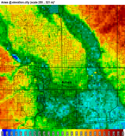
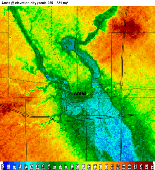
Below is the Elevation map of Ames, which displays elevation range with different colors. Scale of the first map is from 255 to 321 m (837 to 1053 ft) with average elevation of 287.4 meters (=943 ft) [note 1]
These maps also provides idea of topography and contour of this city, they are displayed at different zoom levels. More info about maps, scale and edge coordinates you can find below images.
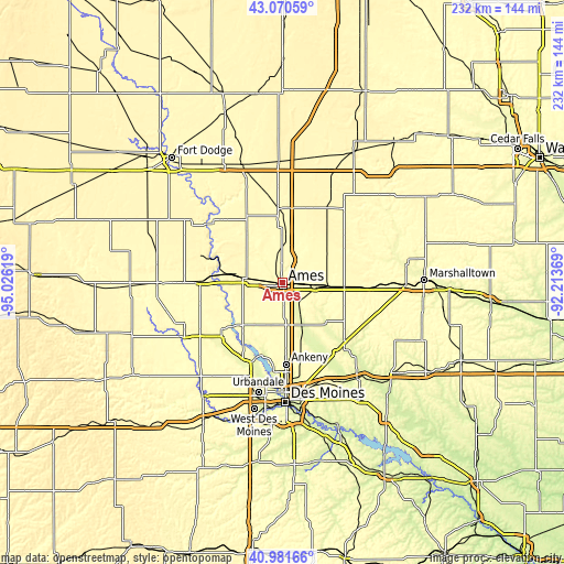
| \ | Map #1 | Map #2 | Topo.Map |
| Scale [m] | 255..321 m | 255..331 m | × |
| Scale [ft] | 837..1053 ft | 837..1086 ft | × |
| Average | 287.4 m = 943 ft | 295.5 m = 969 ft | × |
| Width | 7.26 km = 4.5 mi | 14.52 km = 9 mi | 232.3 km = 144.3 mi |
| Height | 7.26 km = 4.5 mi | 14.52 km = 9 mi | 232.3 km = 144.3 mi |
| ↑Max Latitude | 42.067342° | 42.099956° | 43.07059° |
| Latitude at center | 42.03471° | 42.03471° | 42.03471° |
| ↓Min Latitude | 42.002062° | 41.969397° | 40.98166° |
| ← Min Longitude | -93.663885° | -93.707831° | -95.02619° |
| Longitude center | -93.61994° | -93.61994° | -93.61994° |
| →Max Longitude | -93.575995° | -93.532049° | -92.21369° |
Nearby cities:
Cities around Ames sort by population:
• Boone elevation 343 m
21.7 km,  277°
277°
• Nevada 307 m
13.9 km,  95°
95°
• Centerville 278 m
26.8 km, 283°
• Polk City 267 m
30.3 km,  194°
194°
• Huxley 312 m
15.6 km,  174°
174°
• Story City 310 m
17.1 km,  6°
6°
• Madrid 306 m
24.3 km,  223°
223°
• Slater 312 m
18.1 km,  195°
195°
• Woodward 324 m
31.8 km,  231°
231°
• Roland 313 m
17.6 km,  33°
33°
• Jewell 321 m
30.3 km,  356°
356°
• Gilbert 304 m
8.4 km,  343°
343°
Multilingual:
 En español:
Ames elevación 292 m.
 En France:
Ames élévation 292 m.


Sources and notes:
- [note 1] Map square and city borders are not equal. Map elevation data is calculated only from area inside that square.
- [src 1] Elevation data from geonames database provided with same terms of usage.
- [src 2] The elevation map of Ames is generated using elevation data from NASA's 3 arcsec (90m) resolution SRTM data.
- [src 3] Base (background) map © OpenStreetMap contributors tiles are generated by Geofabrik and OpenTopoMap.
Copyright & License:
This Ames Elevation Map is licensed under CC BY-SA. You may reuse any part from this page, if you give a proper credit by linking to this URL:
 More info on terms of use page.