Camillus elevation
Camillus (New York, Onondaga County), United States elevation is 134 meters and Camillus elevation in feet is 440 ft above sea level [src 1]. Camillus is a populated place (feature code) with elevation that is 145 meters (476 ft) smaller than average city elevation in United States.
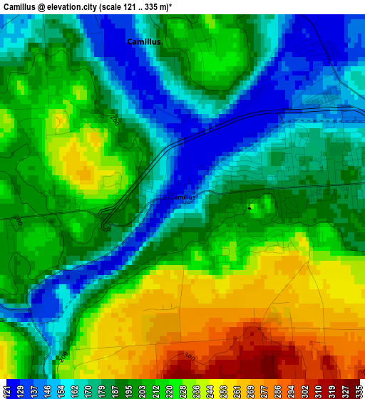
Below is the Elevation map of Camillus, which displays elevation range with different colors. Scale of the first map is from 121 to 335 m (397 to 1099 ft) with average elevation of 201.5 meters (=661 ft) [note 1]
These maps also provides idea of topography and contour of this city, they are displayed at different zoom levels. More info about maps, scale and edge coordinates you can find below images.
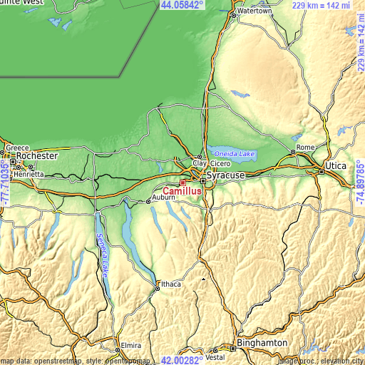
| \ | Map #1 | Topo.Map |
| Scale [m] | 121..335 m | × |
| Scale [ft] | 397..1099 ft | × |
| Average | 201.5 m = 661 ft | × |
| Width | 7.14 km = 4.4 mi | 228.6 km = 142 mi |
| Height | 7.14 km = 4.4 mi | 228.6 km = 142 mi |
| ↑Max Latitude | 43.071341° | 44.05842° |
| Latitude at center | 43.03923° | 43.03923° |
| ↓Min Latitude | 43.007103° | 42.00282° |
| ← Min Longitude | -76.348045° | -77.71035° |
| Longitude center | -76.3041° | -76.3041° |
| →Max Longitude | -76.260155° | -74.89785° |
Nearby cities:
Cities around Camillus sort by population:
• Syracuse elevation 129 m
12.8 km,  85°
85°
• Fairmount 151 m
5.4 km,  80°
80°
• Solvay 155 m
8.1 km, 75°
• Westvale 154 m
6.9 km, 82°
• Galeville 131 m
12.1 km,  62°
62°
• Village Green 135 m
10.5 km,  356°
356°
• Lakeland 148 m
7.7 km,  42°
42°
• Liverpool 131 m
10.3 km, 43°
• Seneca Knolls 127 m
9.1 km,  9°
9°
• Marcellus 208 m
6.9 km,  205°
205°
• Peru 125 m
9.7 km,  299°
299°
• Elbridge 169 m
11.7 km,  267°
267°
Multilingual:
 En español:
Camillus elevación 134 m.
 En France:
Camillus élévation 134 m.
 Auf Deutsch:
Camillus höhe über dem Meeresspiegel ist 134 m.

Sources and notes:
- [note 1] Map square and city borders are not equal. Map elevation data is calculated only from area inside that square.
- [src 1] Elevation data from geonames database provided with same terms of usage.
- [src 2] The elevation map of Camillus is generated using elevation data from NASA's 3 arcsec (90m) resolution SRTM data.
- [src 3] Base (background) map © OpenStreetMap contributors tiles are generated by Geofabrik and OpenTopoMap.
Copyright & License:
This Camillus Elevation Map is licensed under CC BY-SA. You may reuse any part from this page, if you give a proper credit by linking to this URL:
 More info on terms of use page.