Rockland elevation
Rockland (Maine, Knox County), United States elevation is 10 meters and Rockland elevation in feet is 33 ft above sea level [src 1]. Rockland is a seat of a second-order administrative division (feature code) with elevation that is 269 meters (883 ft) smaller than average city elevation in United States.
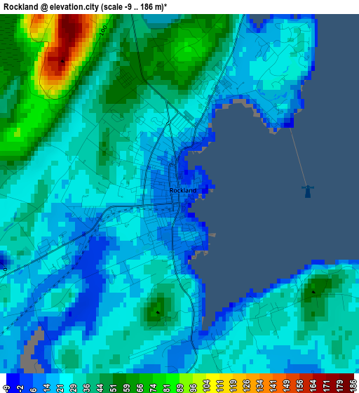
Below is the Elevation map of Rockland, which displays elevation range with different colors. Scale of the first map is from -9 to 186 m (-30 to 610 ft) with average elevation of 33.8 meters (=111 ft) [note 1]
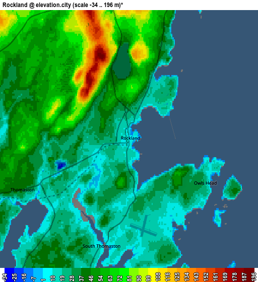
These maps also provides idea of topography and contour of this city, they are displayed at different zoom levels. More info about maps, scale and edge coordinates you can find below images.
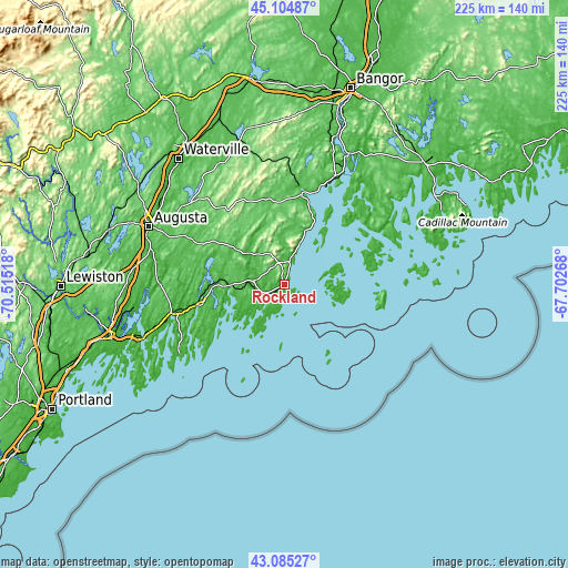
| \ | Map #1 | Map #2 | Topo.Map |
| Scale [m] | -9..186 m | -34..196 m | × |
| Scale [ft] | -30..610 ft | -112..643 ft | × |
| Average | 33.8 m = 111 ft | 42 m = 138 ft | × |
| Width | 7.02 km = 4.4 mi | 14.03 km = 8.7 mi | 224.6 km = 139.6 mi |
| Height | 7.02 km = 4.4 mi | 14.03 km = 8.7 mi | 224.5 km = 139.5 mi |
| ↑Max Latitude | 44.135238° | 44.166769° | 45.10487° |
| Latitude at center | 44.10369° | 44.10369° | 44.10369° |
| ↓Min Latitude | 44.072125° | 44.040544° | 43.08527° |
| ← Min Longitude | -69.152875° | -69.196821° | -70.51518° |
| Longitude center | -69.10893° | -69.10893° | -69.10893° |
| →Max Longitude | -69.064985° | -69.021039° | -67.70268° |
Nearby cities:
Cities around Rockland sort by population:
• Warren elevation 10 m
10.6 km,  280°
280°
• Camden 11 m
12.3 km,  16°
16°
• Rockport 19 m
9.4 km, 16°
• Saint George 36 m
12.1 km,  216°
216°
• Union 29 m
17.8 km,  312°
312°
• Lincolnville 7 m
21.3 km, 22°
• Thomaston 39 m
6.4 km,  244°
244°
• Owls Head 24 m
4.8 km,  119°
119°
• South Thomaston 7 m
6 km,  194°
194°
• Cushing 10 m
14.1 km,  228°
228°
• Hope 109 m
18.4 km,  347°
347°
• Waldoboro 19 m
21.3 km,  267°
267°
Multilingual:
 En español:
Rockland elevación 10 m.
 En France:
Rockland élévation 10 m.


Sources and notes:
- [note 1] Map square and city borders are not equal. Map elevation data is calculated only from area inside that square.
- [src 1] Elevation data from geonames database provided with same terms of usage.
- [src 2] The elevation map of Rockland is generated using elevation data from NASA's 3 arcsec (90m) resolution SRTM data.
- [src 3] Base (background) map © OpenStreetMap contributors tiles are generated by Geofabrik and OpenTopoMap.
Copyright & License:
This Rockland Elevation Map is licensed under CC BY-SA. You may reuse any part from this page, if you give a proper credit by linking to this URL:
 More info on terms of use page.