South Charleston elevation
South Charleston (West Virginia, Kanawha County), United States elevation is 185 meters and South Charleston elevation in feet is 607 ft above sea level [src 1]. South Charleston is a populated place (feature code) with elevation that is 94 meters (308 ft) smaller than average city elevation in United States.
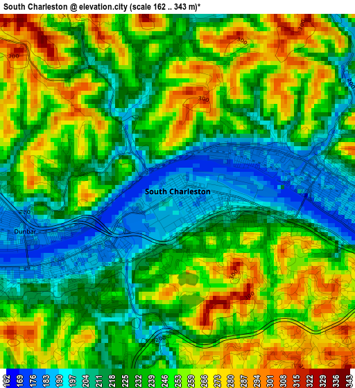
Below is the Elevation map of South Charleston, which displays elevation range with different colors. Scale of the first map is from 162 to 343 m (531 to 1125 ft) with average elevation of 237.8 meters (=780 ft) [note 1]
These maps also provides idea of topography and contour of this city, they are displayed at different zoom levels. More info about maps, scale and edge coordinates you can find below images.
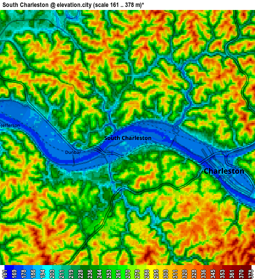
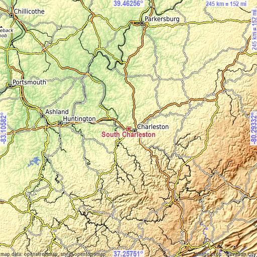
| \ | Map #1 | Map #2 | Topo.Map |
| Scale [m] | 162..343 m | 161..378 m | × |
| Scale [ft] | 531..1125 ft | 528..1240 ft | × |
| Average | 237.8 m = 780 ft | 258.4 m = 848 ft | × |
| Width | 7.66 km = 4.8 mi | 15.32 km = 9.5 mi | 245.2 km = 152.4 mi |
| Height | 7.66 km = 4.8 mi | 15.32 km = 9.5 mi | 245.2 km = 152.4 mi |
| ↑Max Latitude | 38.402876° | 38.437307° | 39.46256° |
| Latitude at center | 38.36843° | 38.36843° | 38.36843° |
| ↓Min Latitude | 38.333967° | 38.299488° | 37.25751° |
| ← Min Longitude | -81.743515° | -81.787461° | -83.10582° |
| Longitude center | -81.69957° | -81.69957° | -81.69957° |
| →Max Longitude | -81.655625° | -81.611679° | -80.29332° |
Nearby cities:
Cities around South Charleston sort by population:
• Charleston elevation 198 m
6.2 km,  109°
109°
• Saint Albans 185 m
12.1 km,  279°
279°
• Cross Lanes 217 m
9.8 km,  306°
306°
• Dunbar 182 m
3.4 km,  255°
255°
• Nitro 184 m
13.6 km,  292°
292°
• Sissonville 190 m
18.7 km,  18°
18°
• Tornado 187 m
12.9 km, 257°
• Pinch 223 m
19.5 km,  76°
76°
• Alum Creek 190 m
12.9 km,  225°
225°
• Rand 193 m
15.3 km,  128°
128°
• Marmet 185 m
17.9 km,  139°
139°
• Coal Fork 195 m
16.6 km, 109°
Multilingual:
 En español:
South Charleston elevación 185 m.
 En France:
South Charleston élévation 185 m.
 Auf Deutsch:
South Charleston höhe über dem Meeresspiegel ist 185 m.

Sources and notes:
- [note 1] Map square and city borders are not equal. Map elevation data is calculated only from area inside that square.
- [src 1] Elevation data from geonames database provided with same terms of usage.
- [src 2] The elevation map of South Charleston is generated using elevation data from NASA's 3 arcsec (90m) resolution SRTM data.
- [src 3] Base (background) map © OpenStreetMap contributors tiles are generated by Geofabrik and OpenTopoMap.
Copyright & License:
This South Charleston Elevation Map is licensed under CC BY-SA. You may reuse any part from this page, if you give a proper credit by linking to this URL:
 More info on terms of use page.