Hurricane elevation
Hurricane (West Virginia, Putnam County), United States elevation is 215 meters and Hurricane elevation in feet is 705 ft above sea level [src 1]. Hurricane is a populated place (feature code) with elevation that is 64 meters (210 ft) smaller than average city elevation in United States.
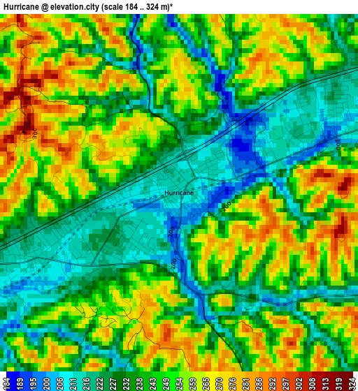
Below is the Elevation map of Hurricane, which displays elevation range with different colors. Scale of the first map is from 184 to 324 m (604 to 1063 ft) with average elevation of 243.2 meters (=798 ft) [note 1]
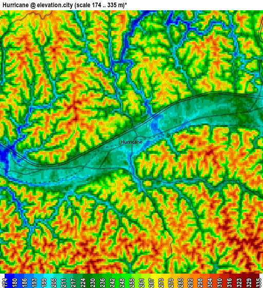
These maps also provides idea of topography and contour of this city, they are displayed at different zoom levels. More info about maps, scale and edge coordinates you can find below images.
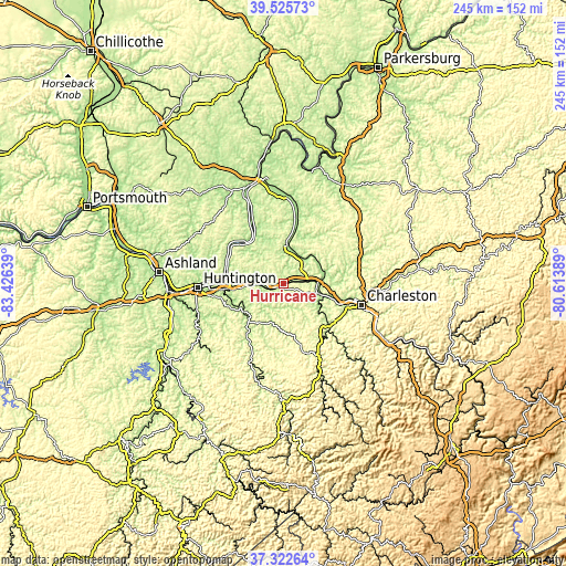
| \ | Map #1 | Map #2 | Topo.Map |
| Scale [m] | 184..324 m | 174..335 m | × |
| Scale [ft] | 604..1063 ft | 571..1099 ft | × |
| Average | 243.2 m = 798 ft | 253.6 m = 832 ft | × |
| Width | 7.66 km = 4.8 mi | 15.31 km = 9.5 mi | 245 km = 152.2 mi |
| Height | 7.66 km = 4.8 mi | 15.31 km = 9.5 mi | 245 km = 152.2 mi |
| ↑Max Latitude | 38.467006° | 38.501405° | 39.52573° |
| Latitude at center | 38.43259° | 38.43259° | 38.43259° |
| ↓Min Latitude | 38.398158° | 38.363709° | 37.32264° |
| ← Min Longitude | -82.064085° | -82.108031° | -83.42639° |
| Longitude center | -82.02014° | -82.02014° | -82.02014° |
| →Max Longitude | -81.976195° | -81.932249° | -80.61389° |
Nearby cities:
Cities around Hurricane sort by population:
• Teays Valley elevation 202 m
8.1 km,  76°
76°
• Saint Albans 185 m
16.9 km,  108°
108°
• Cross Lanes 217 m
20 km,  93°
93°
• Nitro 184 m
15.5 km,  97°
97°
• Barboursville 176 m
24 km,  263°
263°
• Tornado 187 m
18.3 km,  123°
123°
• Culloden 214 m
3.4 km,  245°
245°
• Milton 178 m
9.8 km,  271°
271°
• Winfield 184 m
15.7 km,  44°
44°
• Eleanor 182 m
14 km,  33°
33°
• Buffalo 173 m
20.8 km,  9°
9°
• Hamlin 199 m
18.6 km,  202°
202°
Multilingual:
 En español:
Hurricane elevación 215 m.
 En France:
Hurricane élévation 215 m.
 Auf Deutsch:
Hurricane höhe über dem Meeresspiegel ist 215 m.

Sources and notes:
- [note 1] Map square and city borders are not equal. Map elevation data is calculated only from area inside that square.
- [src 1] Elevation data from geonames database provided with same terms of usage.
- [src 2] The elevation map of Hurricane is generated using elevation data from NASA's 3 arcsec (90m) resolution SRTM data.
- [src 3] Base (background) map © OpenStreetMap contributors tiles are generated by Geofabrik and OpenTopoMap.
Copyright & License:
This Hurricane Elevation Map is licensed under CC BY-SA. You may reuse any part from this page, if you give a proper credit by linking to this URL:
 More info on terms of use page.