Fayetteville elevation
Fayetteville (West Virginia, Fayette County), United States elevation is 551 meters and Fayetteville elevation in feet is 1808 ft above sea level [src 1]. Fayetteville is a seat of a second-order administrative division (feature code) with elevation that is 272 meters (892 ft) bigger than average city elevation in United States.
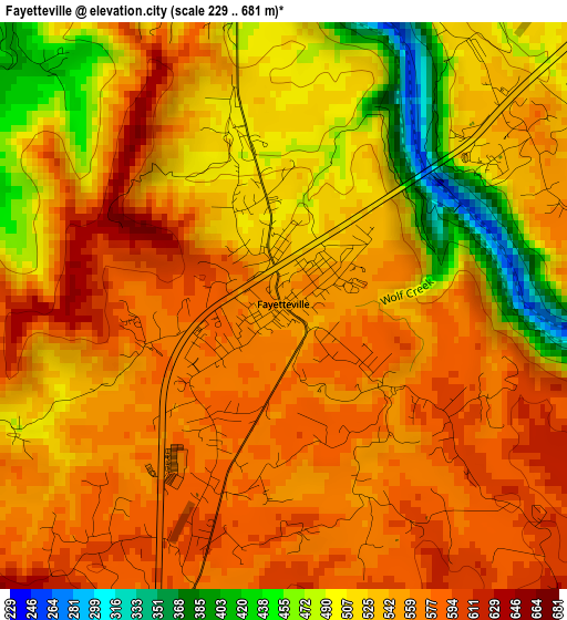
Below is the Elevation map of Fayetteville, which displays elevation range with different colors. Scale of the first map is from 229 to 681 m (751 to 2234 ft) with average elevation of 539.7 meters (=1771 ft) [note 1]
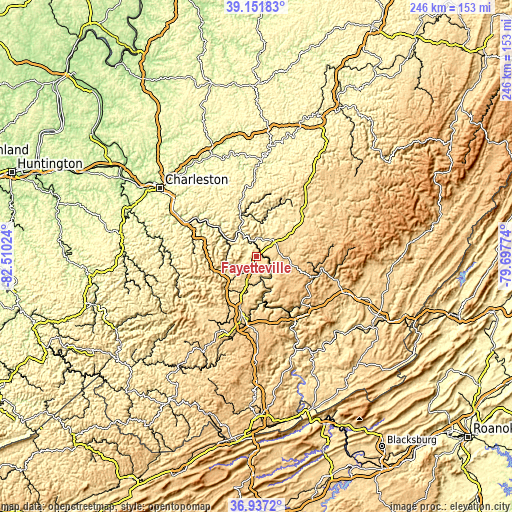
These maps also provides idea of topography and contour of this city, they are displayed at different zoom levels. More info about maps, scale and edge coordinates you can find below images.
| \ | Map #1 | Topo.Map |
| Scale [m] | 229..681 m | × |
| Scale [ft] | 751..2234 ft | × |
| Average | 539.7 m = 1771 ft | × |
| Width | 7.7 km = 4.8 mi | 246.2 km = 153 mi |
| Height | 7.7 km = 4.8 mi | 246.2 km = 153 mi |
| ↑Max Latitude | 38.087486° | 39.15183° |
| Latitude at center | 38.05289° | 38.05289° |
| ↓Min Latitude | 38.018277° | 36.9372° |
| ← Min Longitude | -81.147935° | -82.51024° |
| Longitude center | -81.10399° | -81.10399° |
| →Max Longitude | -81.060045° | -79.69774° |
Nearby cities:
Cities around Fayetteville sort by population:
• Beckley elevation 738 m
31.4 km,  193°
193°
• Oak Hill 610 m
9.8 km,  203°
203°
• Summersville 573 m
33.6 km,  40°
40°
• Bradley 681 m
22.3 km, 200°
• Montgomery 195 m
24.2 km,  305°
305°
• Prosperity 750 m
25.5 km, 199°
• Rainelle 729 m
31 km,  107°
107°
• Ansted 403 m
9.3 km,  2°
2°
• Mount Hope 526 m
18.3 km, 196°
• Mabscott 700 m
32.7 km, 196°
• Stanaford 734 m
26.7 km, 189°
• Beaver 657 m
34.1 km, 185°
Multilingual:
 En español:
Fayetteville elevación 551 m.
 En France:
Fayetteville élévation 551 m.
 Auf Deutsch:
Fayetteville höhe über dem Meeresspiegel ist 551 m.

Sources and notes:
- [note 1] Map square and city borders are not equal. Map elevation data is calculated only from area inside that square.
- [src 1] Elevation data from geonames database provided with same terms of usage.
- [src 2] The elevation map of Fayetteville is generated using elevation data from NASA's 3 arcsec (90m) resolution SRTM data.
- [src 3] Base (background) map © OpenStreetMap contributors tiles are generated by Geofabrik and OpenTopoMap.
Copyright & License:
This Fayetteville Elevation Map is licensed under CC BY-SA. You may reuse any part from this page, if you give a proper credit by linking to this URL:
 More info on terms of use page.