West Point elevation
West Point (Virginia, King William County), United States elevation is 5 meters and West Point elevation in feet is 16 ft above sea level [src 1]. West Point is a populated place (feature code) with elevation that is 274 meters (899 ft) smaller than average city elevation in United States.
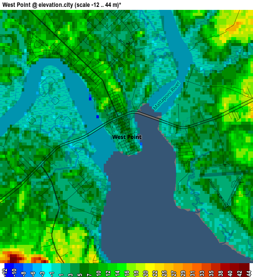
Below is the Elevation map of West Point, which displays elevation range with different colors. Scale of the first map is from -12 to 44 m (-39 to 144 ft) with average elevation of 6 meters (=20 ft) [note 1]
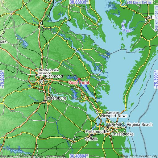
These maps also provides idea of topography and contour of this city, they are displayed at different zoom levels. More info about maps, scale and edge coordinates you can find below images.
| \ | Map #1 | Topo.Map |
| Scale [m] | -12..44 m | × |
| Scale [ft] | -39..144 ft | × |
| Average | 6 m = 20 ft | × |
| Width | 7.75 km = 4.8 mi | 248 km = 154.1 mi |
| Height | 7.75 km = 4.8 mi | 248 km = 154.1 mi |
| ↑Max Latitude | 37.566371° | 38.63835° |
| Latitude at center | 37.53153° | 37.53153° |
| ↓Min Latitude | 37.496672° | 36.40804° |
| ← Min Longitude | -76.840295° | -78.2026° |
| Longitude center | -76.79635° | -76.79635° |
| →Max Longitude | -76.752405° | -75.3901° |
Nearby cities:
Cities around West Point sort by population:
• Williamsburg elevation 33 m
30 km,  164°
164°
• Gloucester Point 15 m
40.6 km,  139°
139°
• Gloucester Courthouse 25 m
27.4 km,  119°
119°
• Central Garage 51 m
37.8 km,  308°
308°
• Deltaville 10 m
40.6 km,  86°
86°
• Saluda 31 m
19.6 km,  64°
64°
• King William 45 m
25.8 km, 312°
• New Kent 44 m
16.2 km,  264°
264°
• Yorktown 4 m
41.2 km, 142°
• Charles City 13 m
32.2 km,  229°
229°
• King and Queen Court House 12 m
17 km,  335°
335°
• Lancaster 23 m
39.3 km,  47°
47°
Multilingual:
 En español:
West Point elevación 5 m.
 En France:
West Point élévation 5 m.
 Auf Deutsch:
West Point höhe über dem Meeresspiegel ist 5 m.

Sources and notes:
- [note 1] Map square and city borders are not equal. Map elevation data is calculated only from area inside that square.
- [src 1] Elevation data from geonames database provided with same terms of usage.
- [src 2] The elevation map of West Point is generated using elevation data from NASA's 3 arcsec (90m) resolution SRTM data.
- [src 3] Base (background) map © OpenStreetMap contributors tiles are generated by Geofabrik and OpenTopoMap.
Copyright & License:
This West Point Elevation Map is licensed under CC BY-SA. You may reuse any part from this page, if you give a proper credit by linking to this URL:
 More info on terms of use page.