Massanetta Springs elevation
Massanetta Springs (Virginia, Rockingham County), United States elevation is 453 meters and Massanetta Springs elevation in feet is 1486 ft above sea level [src 1]. Massanetta Springs is a populated place (feature code) with elevation that is 174 meters (571 ft) bigger than average city elevation in United States.
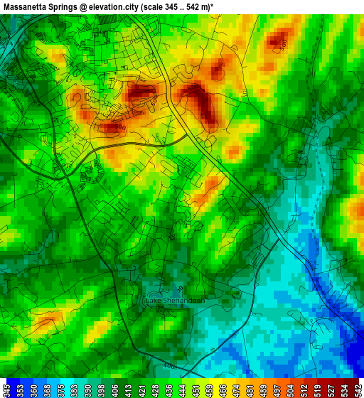
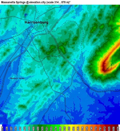
Below is the Elevation map of Massanetta Springs, which displays elevation range with different colors. Scale of the first map is from 345 to 542 m (1132 to 1778 ft) with average elevation of 426.3 meters (=1399 ft) [note 1]
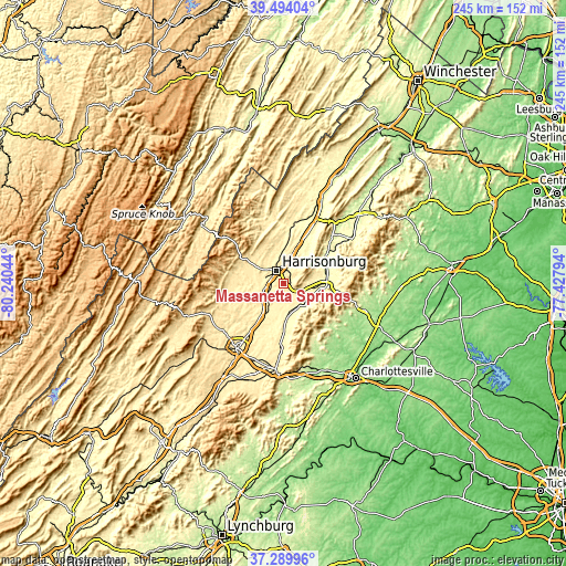
These maps also provides idea of topography and contour of this city, they are displayed at different zoom levels. More info about maps, scale and edge coordinates you can find below images.
| \ | Map #1 | Map #2 | Topo.Map |
| Scale [m] | 345..542 m | 314..878 m | × |
| Scale [ft] | 1132..1778 ft | 1030..2881 ft | × |
| Average | 426.3 m = 1399 ft | 423.1 m = 1388 ft | × |
| Width | 7.66 km = 4.8 mi | 15.32 km = 9.5 mi | 245.1 km = 152.3 mi |
| Height | 7.66 km = 4.8 mi | 15.32 km = 9.5 mi | 245.1 km = 152.3 mi |
| ↑Max Latitude | 38.434831° | 38.469246° | 39.49404° |
| Latitude at center | 38.4004° | 38.4004° | 38.4004° |
| ↓Min Latitude | 38.365952° | 38.331488° | 37.28996° |
| ← Min Longitude | -78.878135° | -78.922081° | -80.24044° |
| Longitude center | -78.83419° | -78.83419° | -78.83419° |
| →Max Longitude | -78.790245° | -78.746299° | -77.42794° |
Nearby cities:
Cities around Massanetta Springs sort by population:
• Harrisonburg elevation 406 m
6.2 km,  331°
331°
• Bridgewater 360 m
12.6 km,  260°
260°
• Verona 390 m
26.8 km,  214°
214°
• Broadway 315 m
23.9 km,  7°
7°
• Elkton 294 m
18.4 km,  87°
87°
• Grottoes 339 m
14.8 km,  177°
177°
• Timberville 310 m
27 km, 11°
• Weyers Cave 355 m
14.2 km, 208°
• Shenandoah 296 m
20.5 km,  62°
62°
• Massanutten 510 m
8.5 km,  83°
83°
• Dayton 367 m
9.2 km,  280°
280°
• Belmont Estates 427 m
9.5 km,  307°
307°
Multilingual:
 En español:
Massanetta Springs elevación 453 m.
 En France:
Massanetta Springs élévation 453 m.
 Auf Deutsch:
Massanetta Springs höhe über dem Meeresspiegel ist 453 m.
 На русском:
Massanetta Springs высота над уровнем моря 453 м
Sources and notes:
- [note 1] Map square and city borders are not equal. Map elevation data is calculated only from area inside that square.
- [src 1] Elevation data from geonames database provided with same terms of usage.
- [src 2] The elevation map of Massanetta Springs is generated using elevation data from NASA's 3 arcsec (90m) resolution SRTM data.
- [src 3] Base (background) map © OpenStreetMap contributors tiles are generated by Geofabrik and OpenTopoMap.
Copyright & License:
This Massanetta Springs Elevation Map is licensed under CC BY-SA. You may reuse any part from this page, if you give a proper credit by linking to this URL:
 More info on terms of use page.