Loch Lomond elevation
Loch Lomond (Virginia, Prince William County), United States elevation is 57 meters and Loch Lomond elevation in feet is 187 ft above sea level [src 1]. Loch Lomond is a populated place (feature code) with elevation that is 222 meters (728 ft) smaller than average city elevation in United States.
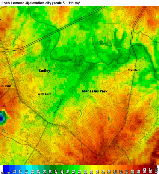
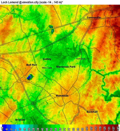
Below is the Elevation map of Loch Lomond, which displays elevation range with different colors. Scale of the first map is from 5 to 111 m (16 to 364 ft) with average elevation of 68.7 meters (=225 ft) [note 1]
These maps also provides idea of topography and contour of this city, they are displayed at different zoom levels. More info about maps, scale and edge coordinates you can find below images.
| \ | Map #1 | Map #2 | Topo.Map |
| Scale [m] | 5..111 m | -14..143 m | × |
| Scale [ft] | 16..364 ft | -46..469 ft | × |
| Average | 68.7 m = 225 ft | 79.2 m = 260 ft | × |
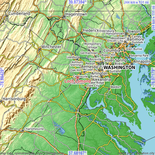
| Width | 7.62 km = 4.7 mi | 15.24 km = 9.5 mi | 243.8 km = 151.5 mi |
| Height | 7.62 km = 4.7 mi | 15.24 km = 9.5 mi | 243.8 km = 151.5 mi |
| ↑Max Latitude | 38.820477° | 38.854707° | 39.87394° |
| Latitude at center | 38.78623° | 38.78623° | 38.78623° |
| ↓Min Latitude | 38.751967° | 38.717687° | 37.68167° |
| ← Min Longitude | -77.521985° | -77.565931° | -78.88429° |
| Longitude center | -77.47804° | -77.47804° | -77.47804° |
| →Max Longitude | -77.434095° | -77.390149° | -76.07179° |
Nearby cities:
Cities around Loch Lomond sort by population:
• Centreville elevation 110 m
7.4 km,  35°
35°
• Manassas 94 m
3.9 km,  176°
176°
• Linton Hall 80 m
8.9 km,  250°
250°
• Chantilly 100 m
12.7 km,  18°
18°
• Buckhall 96 m
7.3 km,  146°
146°
• Sudley 65 m
1.8 km,  293°
293°
• Manassas Park 62 m
0.8 km,  108°
108°
• Bull Run 92 m
3.7 km,  265°
265°
• Gainesville 111 m
11.8 km,  275°
275°
• Greenbriar 112 m
11.8 km,  34°
34°
• West Gate 65 m
1.7 km,  257°
257°
• Yorkshire 65 m
2.7 km,  73°
73°
Multilingual:
 En español:
Loch Lomond elevación 57 m.
 En France:
Loch Lomond élévation 57 m.
 Auf Deutsch:
Loch Lomond höhe über dem Meeresspiegel ist 57 m.

Sources and notes:
- [note 1] Map square and city borders are not equal. Map elevation data is calculated only from area inside that square.
- [src 1] Elevation data from geonames database provided with same terms of usage.
- [src 2] The elevation map of Loch Lomond is generated using elevation data from NASA's 3 arcsec (90m) resolution SRTM data.
- [src 3] Base (background) map © OpenStreetMap contributors tiles are generated by Geofabrik and OpenTopoMap.
Copyright & License:
This Loch Lomond Elevation Map is licensed under CC BY-SA. You may reuse any part from this page, if you give a proper credit by linking to this URL:
 More info on terms of use page.