Bensley elevation
Bensley (Virginia, Chesterfield County), United States elevation is 20 meters and Bensley elevation in feet is 66 ft above sea level [src 1]. Bensley is a populated place (feature code) with elevation that is 259 meters (850 ft) smaller than average city elevation in United States.
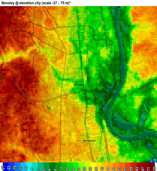
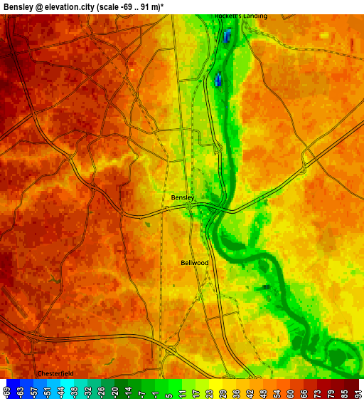
Below is the Elevation map of Bensley, which displays elevation range with different colors. Scale of the first map is from -27 to 75 m (-89 to 246 ft) with average elevation of 34.9 meters (=115 ft) [note 1]
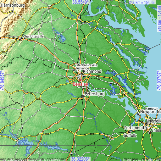
These maps also provides idea of topography and contour of this city, they are displayed at different zoom levels. More info about maps, scale and edge coordinates you can find below images.
| \ | Map #1 | Map #2 | Topo.Map |
| Scale [m] | -27..75 m | -69..91 m | × |
| Scale [ft] | -89..246 ft | -226..299 ft | × |
| Average | 34.9 m = 115 ft | 43.4 m = 142 ft | × |
| Width | 7.76 km = 4.8 mi | 15.52 km = 9.6 mi | 248.3 km = 154.3 mi |
| Height | 7.76 km = 4.8 mi | 15.52 km = 9.6 mi | 248.3 km = 154.3 mi |
| ↑Max Latitude | 37.481691° | 37.516555° | 38.5549° |
| Latitude at center | 37.44681° | 37.44681° | 37.44681° |
| ↓Min Latitude | 37.411913° | 37.377° | 36.32206° |
| ← Min Longitude | -77.487265° | -77.531211° | -78.84957° |
| Longitude center | -77.44332° | -77.44332° | -77.44332° |
| →Max Longitude | -77.399375° | -77.355429° | -76.03707° |
Nearby cities:
Cities around Bensley sort by population:
• Richmond elevation 68 m
12 km,  352°
352°
• Chester 55 m
10 km,  179°
179°
• Meadowbrook 64 m
2.7 km,  274°
274°
• Bon Air 101 m
13.3 km,  310°
310°
• Highland Springs 52 m
15 km,  42°
42°
• East Highland Park 62 m
15.3 km,  12°
12°
• Montrose 45 m
10 km,  34°
34°
• Sandston 51 m
14.1 km,  52°
52°
• Fort Lee 51 m
11 km,  60°
60°
• Bellwood 32 m
2.8 km,  169°
169°
• Chesterfield Court House 62 m
9.5 km,  215°
215°
• Chesterfield 63 m
9.5 km, 215°
Multilingual:
 En español:
Bensley elevación 20 m.
 En France:
Bensley élévation 20 m.


Sources and notes:
- [note 1] Map square and city borders are not equal. Map elevation data is calculated only from area inside that square.
- [src 1] Elevation data from geonames database provided with same terms of usage.
- [src 2] The elevation map of Bensley is generated using elevation data from NASA's 3 arcsec (90m) resolution SRTM data.
- [src 3] Base (background) map © OpenStreetMap contributors tiles are generated by Geofabrik and OpenTopoMap.
Copyright & License:
This Bensley Elevation Map is licensed under CC BY-SA. You may reuse any part from this page, if you give a proper credit by linking to this URL:
 More info on terms of use page.