Bedford elevation
Bedford (Virginia, City of Bedford), United States elevation is 307 meters and Bedford elevation in feet is 1007 ft above sea level [src 1]. Bedford is a seat of a second-order administrative division (feature code) with elevation that is 28 meters (92 ft) bigger than average city elevation in United States.
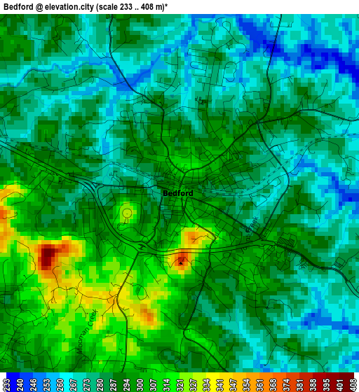
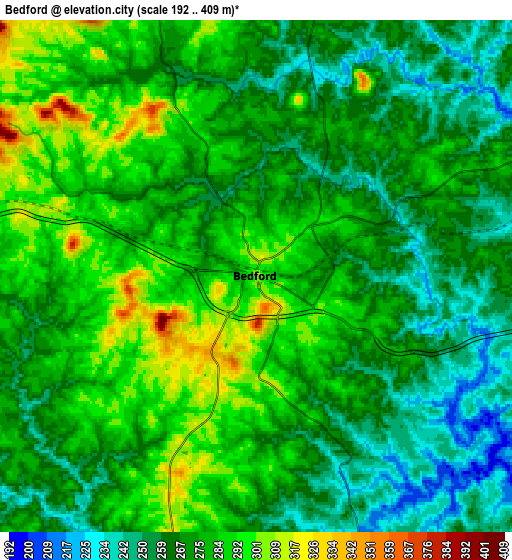
Below is the Elevation map of Bedford, which displays elevation range with different colors. Scale of the first map is from 233 to 408 m (764 to 1339 ft) with average elevation of 287.4 meters (=943 ft) [note 1]
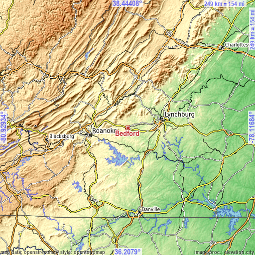
These maps also provides idea of topography and contour of this city, they are displayed at different zoom levels. More info about maps, scale and edge coordinates you can find below images.
| \ | Map #1 | Map #2 | Topo.Map |
| Scale [m] | 233..408 m | 192..409 m | × |
| Scale [ft] | 764..1339 ft | 630..1342 ft | × |
| Average | 287.4 m = 943 ft | 273.6 m = 898 ft | × |
| Width | 7.77 km = 4.8 mi | 15.54 km = 9.7 mi | 248.6 km = 154.5 mi |
| Height | 7.77 km = 4.8 mi | 15.54 km = 9.7 mi | 248.6 km = 154.5 mi |
| ↑Max Latitude | 37.369243° | 37.40416° | 38.44408° |
| Latitude at center | 37.33431° | 37.33431° | 37.33431° |
| ↓Min Latitude | 37.29936° | 37.264395° | 36.2079° |
| ← Min Longitude | -79.567035° | -79.610981° | -80.92934° |
| Longitude center | -79.52309° | -79.52309° | -79.52309° |
| →Max Longitude | -79.479145° | -79.435199° | -78.11684° |
Nearby cities:
Cities around Bedford sort by population:
• West Lynchburg elevation 225 m
31.4 km,  75°
75°
• Timberlake 282 m
23.5 km,  93°
93°
• Forest 265 m
20.9 km, 80°
• Vinton 280 m
33.6 km,  259°
259°
• Altavista 163 m
32.5 km,  139°
139°
• North Shore 308 m
30.5 km,  203°
203°
• Blue Ridge 387 m
25.6 km,  281°
281°
• Laymantown 413 m
29.8 km, 276°
• Hurt 222 m
33.5 km, 143°
• Buchanan 258 m
25.5 km,  327°
327°
• Glasgow 224 m
33.9 km,  10°
10°
• Motley 242 m
33.6 km,  151°
151°
Multilingual:
 En español:
Bedford elevación 307 m.
 En France:
Bedford élévation 307 m.


Sources and notes:
- [note 1] Map square and city borders are not equal. Map elevation data is calculated only from area inside that square.
- [src 1] Elevation data from geonames database provided with same terms of usage.
- [src 2] The elevation map of Bedford is generated using elevation data from NASA's 3 arcsec (90m) resolution SRTM data.
- [src 3] Base (background) map © OpenStreetMap contributors tiles are generated by Geofabrik and OpenTopoMap.
Copyright & License:
This Bedford Elevation Map is licensed under CC BY-SA. You may reuse any part from this page, if you give a proper credit by linking to this URL:
 More info on terms of use page.