Throckmorton elevation
Throckmorton (Texas, Throckmorton County), United States elevation is 407 meters and Throckmorton elevation in feet is 1335 ft above sea level [src 1]. Throckmorton is a seat of a second-order administrative division (feature code) with elevation that is 128 meters (420 ft) bigger than average city elevation in United States.
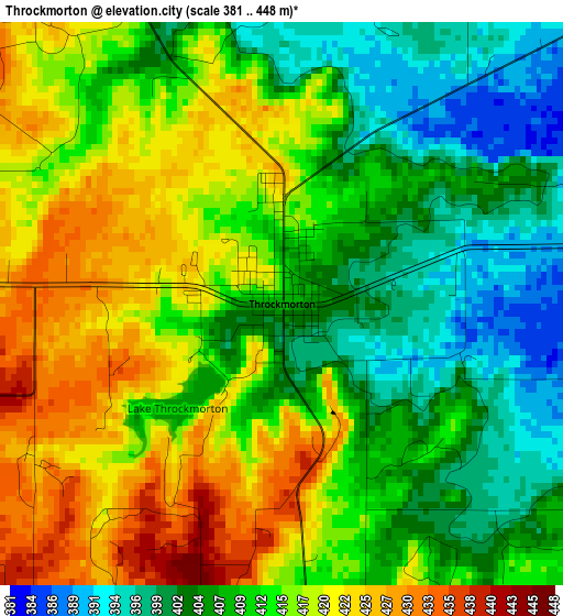
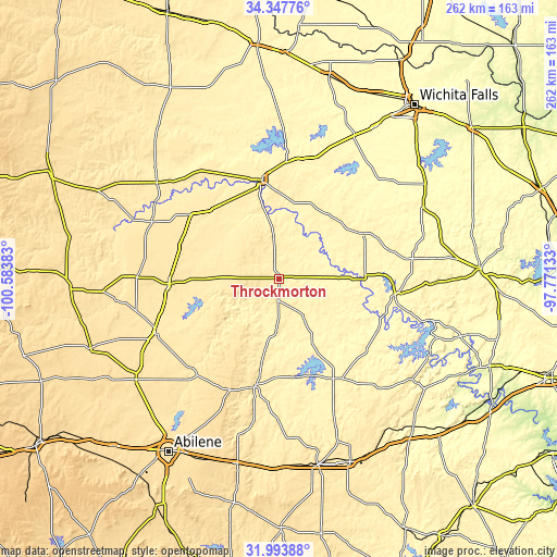
Below is the Elevation map of Throckmorton, which displays elevation range with different colors. Scale of the first map is from 381 to 448 m (1250 to 1470 ft) with average elevation of 412.1 meters (=1352 ft) [note 1]
These maps also provides idea of topography and contour of this city, they are displayed at different zoom levels. More info about maps, scale and edge coordinates you can find below images.
| \ | Map #1 | Topo.Map |
| Scale [m] | 381..448 m | × |
| Scale [ft] | 1250..1470 ft | × |
| Average | 412.1 m = 1352 ft | × |
| Width | 8.18 km = 5.1 mi | 261.7 km = 162.6 mi |
| Height | 8.18 km = 5.1 mi | 261.7 km = 162.6 mi |
| ↑Max Latitude | 33.215493° | 34.34776° |
| Latitude at center | 33.17872° | 33.17872° |
| ↓Min Latitude | 33.141931° | 31.99388° |
| ← Min Longitude | -99.221525° | -100.58383° |
| Longitude center | -99.17758° | -99.17758° |
| →Max Longitude | -99.133635° | -97.77133° |
Nearby cities:
Cities around Throckmorton sort by population:
• Graham elevation 327 m
55.3 km,  98°
98°
• Breckenridge 372 m
53.6 km,  151°
151°
• Haskell 483 m
51.8 km,  267°
267°
• Olney 367 m
44.9 km,  61°
61°
• Stamford 497 m
63.8 km,  245°
245°
• Seymour 399 m
46.8 km,  350°
350°
• Anson 532 m
81.8 km,  234°
234°
• Albany 434 m
51.8 km,  192°
192°
• Archer City 331 m
69.1 km,  47°
47°
• Munday 455 m
51.2 km,  306°
306°
• Knox City 467 m
65.3 km,  294°
294°
• Benjamin 452 m
72.7 km, 308°
Multilingual:
 En español:
Throckmorton elevación 407 m.
 En France:
Throckmorton élévation 407 m.
 Auf Deutsch:
Throckmorton höhe über dem Meeresspiegel ist 407 m.

Sources and notes:
- [note 1] Map square and city borders are not equal. Map elevation data is calculated only from area inside that square.
- [src 1] Elevation data from geonames database provided with same terms of usage.
- [src 2] The elevation map of Throckmorton is generated using elevation data from NASA's 3 arcsec (90m) resolution SRTM data.
- [src 3] Base (background) map © OpenStreetMap contributors tiles are generated by Geofabrik and OpenTopoMap.
Copyright & License:
This Throckmorton Elevation Map is licensed under CC BY-SA. You may reuse any part from this page, if you give a proper credit by linking to this URL:
 More info on terms of use page.