Selma elevation
Selma (Texas, Bexar County), United States elevation is 229 meters and Selma elevation in feet is 751 ft above sea level [src 1]. Selma is a populated place (feature code) with elevation that is 50 meters (164 ft) smaller than average city elevation in United States.
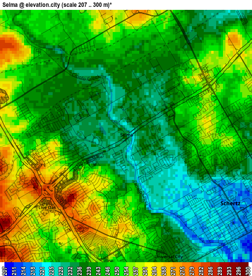
Below is the Elevation map of Selma, which displays elevation range with different colors. Scale of the first map is from 207 to 300 m (679 to 984 ft) with average elevation of 245.5 meters (=805 ft) [note 1]
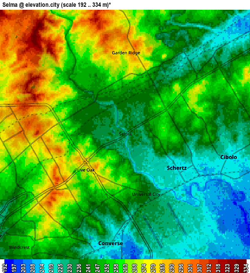
These maps also provides idea of topography and contour of this city, they are displayed at different zoom levels. More info about maps, scale and edge coordinates you can find below images.
| \ | Map #1 | Map #2 | Topo.Map |
| Scale [m] | 207..300 m | 192..334 m | × |
| Scale [ft] | 679..984 ft | 630..1096 ft | × |
| Average | 245.5 m = 805 ft | 249.7 m = 819 ft | × |
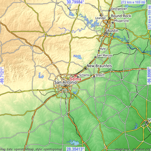
| Width | 8.5 km = 5.3 mi | 17 km = 10.6 mi | 271.9 km = 169 mi |
| Height | 8.5 km = 5.3 mi | 17 km = 10.6 mi | 271.9 km = 169 mi |
| ↑Max Latitude | 29.622599° | 29.660793° | 30.79984° |
| Latitude at center | 29.58439° | 29.58439° | 29.58439° |
| ↓Min Latitude | 29.546167° | 29.507929° | 28.35413° |
| ← Min Longitude | -98.349795° | -98.393741° | -99.7121° |
| Longitude center | -98.30585° | -98.30585° | -98.30585° |
| →Max Longitude | -98.261905° | -98.217959° | -96.8996° |
Nearby cities:
Cities around Selma sort by population:
• Schertz elevation 220 m
5 km,  135°
135°
• Cibolo 217 m
8 km,  108°
108°
• Converse 222 m
7.4 km,  187°
187°
• Universal City 236 m
4.3 km,  160°
160°
• Live Oak 278 m
3.6 km,  234°
234°
• Kirby 214 m
15.5 km,  209°
209°
• Windcrest 245 m
10.5 km,  223°
223°
• Garden Ridge 278 m
5.6 km,  0°
0°
• Hollywood Park 301 m
17.6 km,  275°
275°
• Northcliff 253 m
8.8 km,  62°
62°
• Marion 199 m
16.1 km,  95°
95°
• Hill Country Village 291 m
17.9 km,  269°
269°
Multilingual:
 En español:
Selma elevación 229 m.
 En France:
Selma élévation 229 m.


Sources and notes:
- [note 1] Map square and city borders are not equal. Map elevation data is calculated only from area inside that square.
- [src 1] Elevation data from geonames database provided with same terms of usage.
- [src 2] The elevation map of Selma is generated using elevation data from NASA's 3 arcsec (90m) resolution SRTM data.
- [src 3] Base (background) map © OpenStreetMap contributors tiles are generated by Geofabrik and OpenTopoMap.
Copyright & License:
This Selma Elevation Map is licensed under CC BY-SA. You may reuse any part from this page, if you give a proper credit by linking to this URL:
 More info on terms of use page.