Rosenberg elevation
Rosenberg (Texas, Fort Bend County), United States elevation is 35 meters and Rosenberg elevation in feet is 115 ft above sea level [src 1]. Rosenberg is a populated place (feature code) with elevation that is 244 meters (801 ft) smaller than average city elevation in United States.
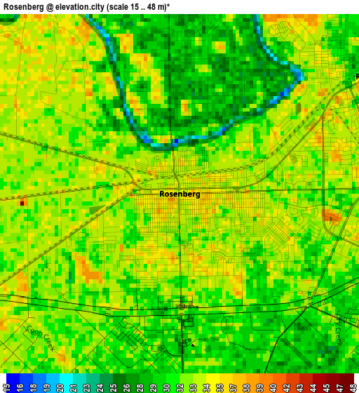
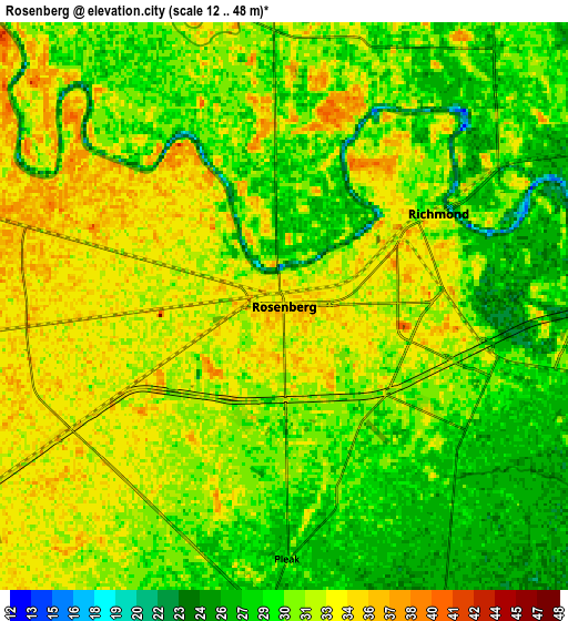
Below is the Elevation map of Rosenberg, which displays elevation range with different colors. Scale of the first map is from 15 to 48 m (49 to 157 ft) with average elevation of 31.9 meters (=105 ft) [note 1]
These maps also provides idea of topography and contour of this city, they are displayed at different zoom levels. More info about maps, scale and edge coordinates you can find below images.
| \ | Map #1 | Map #2 | Topo.Map |
| Scale [m] | 15..48 m | 12..48 m | × |
| Scale [ft] | 49..157 ft | 39..157 ft | × |
| Average | 31.9 m = 105 ft | 30.8 m = 101 ft | × |
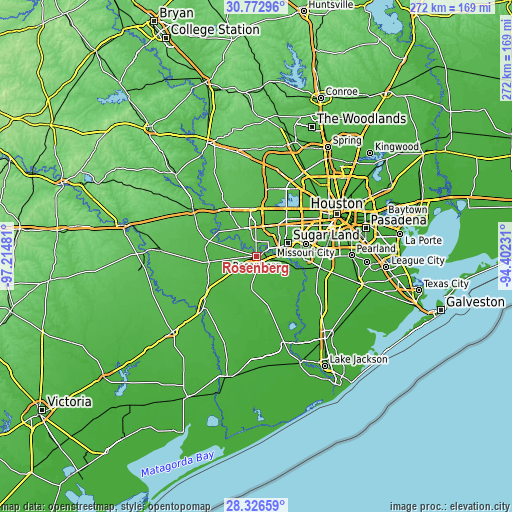
| Width | 8.5 km = 5.3 mi | 17 km = 10.6 mi | 272 km = 169 mi |
| Height | 8.5 km = 5.3 mi | 17 km = 10.6 mi | 272 km = 169 mi |
| ↑Max Latitude | 29.595399° | 29.633604° | 30.77296° |
| Latitude at center | 29.55718° | 29.55718° | 29.55718° |
| ↓Min Latitude | 29.518946° | 29.480698° | 28.32659° |
| ← Min Longitude | -95.852505° | -95.896451° | -97.21481° |
| Longitude center | -95.80856° | -95.80856° | -95.80856° |
| →Max Longitude | -95.764615° | -95.720669° | -94.40231° |
Nearby cities:
Cities around Rosenberg sort by population:
• Sugar Land elevation 32 m
18.2 km,  67°
67°
• Mission Bend 30 m
20.6 km,  42°
42°
• Pecan Grove 29 m
10.7 km, 44°
• New Territory 26 m
13 km, 71°
• Four Corners 31 m
19.1 km,  49°
49°
• Richmond 31 m
5.4 km,  58°
58°
• Greatwood 25 m
12.8 km,  91°
91°
• Fulshear 43 m
17.2 km,  329°
329°
• Needville 31 m
17.8 km,  189°
189°
• Weston Lakes 35 m
18.6 km,  318°
318°
• Pleak 29 m
7.6 km,  179°
179°
• Fairchilds 26 m
14.3 km,  168°
168°
Multilingual:
 En español:
Rosenberg elevación 35 m.
 En France:
Rosenberg élévation 35 m.
 Auf Deutsch:
Rosenberg höhe über dem Meeresspiegel ist 35 m.

Sources and notes:
- [note 1] Map square and city borders are not equal. Map elevation data is calculated only from area inside that square.
- [src 1] Elevation data from geonames database provided with same terms of usage.
- [src 2] The elevation map of Rosenberg is generated using elevation data from NASA's 3 arcsec (90m) resolution SRTM data.
- [src 3] Base (background) map © OpenStreetMap contributors tiles are generated by Geofabrik and OpenTopoMap.
Copyright & License:
This Rosenberg Elevation Map is licensed under CC BY-SA. You may reuse any part from this page, if you give a proper credit by linking to this URL:
 More info on terms of use page.