Paris elevation
Paris (Texas, Lamar County), United States elevation is 190 meters and Paris elevation in feet is 623 ft above sea level [src 1]. Paris is a seat of a second-order administrative division (feature code) with elevation that is 89 meters (292 ft) smaller than average city elevation in United States.
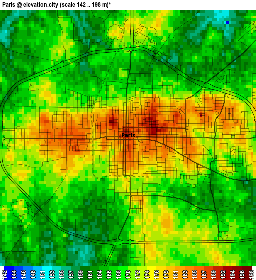
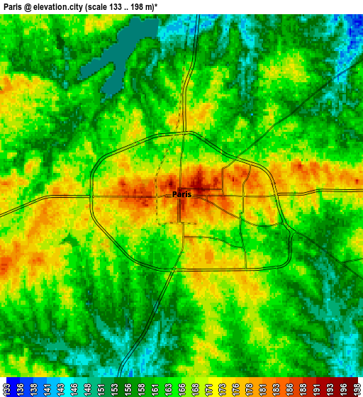
Below is the Elevation map of Paris, which displays elevation range with different colors. Scale of the first map is from 142 to 198 m (466 to 650 ft) with average elevation of 169.6 meters (=556 ft) [note 1]
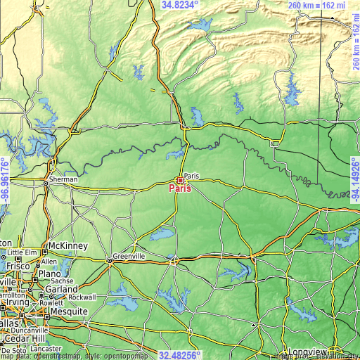
These maps also provides idea of topography and contour of this city, they are displayed at different zoom levels. More info about maps, scale and edge coordinates you can find below images.
| \ | Map #1 | Map #2 | Topo.Map |
| Scale [m] | 142..198 m | 133..198 m | × |
| Scale [ft] | 466..650 ft | 436..650 ft | × |
| Average | 169.6 m = 556 ft | 162.5 m = 533 ft | × |
| Width | 8.13 km = 5.1 mi | 16.27 km = 10.1 mi | 260.3 km = 161.7 mi |
| Height | 8.13 km = 5.1 mi | 16.27 km = 10.1 mi | 260.3 km = 161.7 mi |
| ↑Max Latitude | 33.697509° | 33.734063° | 34.8234° |
| Latitude at center | 33.66094° | 33.66094° | 33.66094° |
| ↓Min Latitude | 33.624355° | 33.587755° | 32.48256° |
| ← Min Longitude | -95.599455° | -95.643401° | -96.96176° |
| Longitude center | -95.55551° | -95.55551° | -95.55551° |
| →Max Longitude | -95.511565° | -95.467619° | -94.14926° |
Nearby cities:
Cities around Paris sort by population:
• Sulphur Springs elevation 158 m
58.2 km,  184°
184°
• Commerce 172 m
56 km,  214°
214°
• Hugo 169 m
39.1 km,  6°
6°
• Reno 175 m
8.6 km,  88°
88°
• Clarksville 128 m
46.9 km,  96°
96°
• Cooper 154 m
34.3 km,  201°
201°
• Honey Grove 209 m
33.9 km,  255°
255°
• Lone Star 158 m
20.8 km,  48°
48°
• Blossom 167 m
15.7 km, 89°
• Wolfe City 215 m
57.5 km,  235°
235°
• Powderly 166 m
17 km, 9°
• Bogata 134 m
38.1 km,  123°
123°
Multilingual:
 En español:
Paris elevación 190 m.
 En France:
Paris élévation 190 m.


Sources and notes:
- [note 1] Map square and city borders are not equal. Map elevation data is calculated only from area inside that square.
- [src 1] Elevation data from geonames database provided with same terms of usage.
- [src 2] The elevation map of Paris is generated using elevation data from NASA's 3 arcsec (90m) resolution SRTM data.
- [src 3] Base (background) map © OpenStreetMap contributors tiles are generated by Geofabrik and OpenTopoMap.
Copyright & License:
This Paris Elevation Map is licensed under CC BY-SA. You may reuse any part from this page, if you give a proper credit by linking to this URL:
 More info on terms of use page.