Mount Pleasant elevation
Mount Pleasant (Texas, Titus County), United States elevation is 126 meters and Mount Pleasant elevation in feet is 413 ft above sea level [src 1]. Mount Pleasant is a seat of a second-order administrative division (feature code) with elevation that is 153 meters (502 ft) smaller than average city elevation in United States.
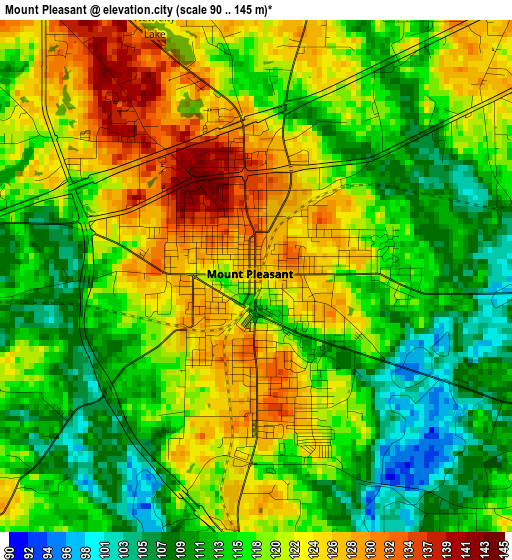
Below is the Elevation map of Mount Pleasant, which displays elevation range with different colors. Scale of the first map is from 90 to 145 m (295 to 476 ft) with average elevation of 117.9 meters (=387 ft) [note 1]
These maps also provides idea of topography and contour of this city, they are displayed at different zoom levels. More info about maps, scale and edge coordinates you can find below images.
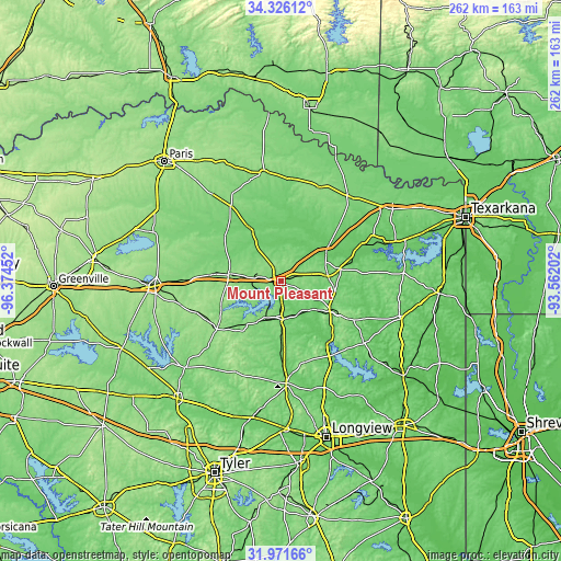
| \ | Map #1 | Map #2 | Topo.Map |
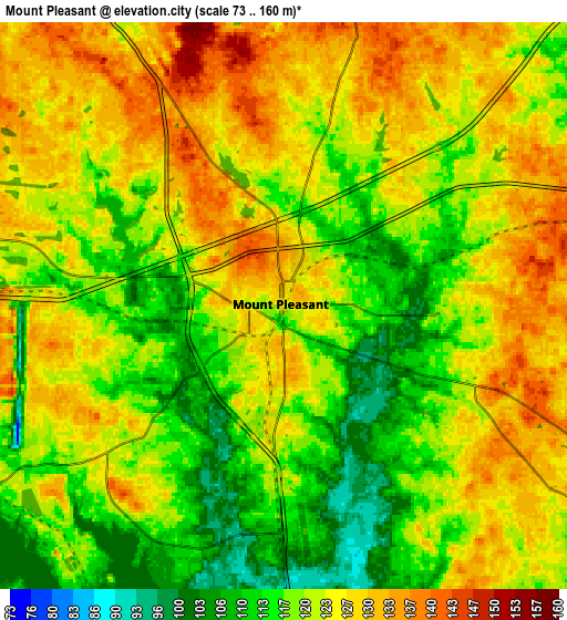
| Scale [m] | 90..145 m | 73..160 m | × |
| Scale [ft] | 295..476 ft | 240..525 ft | × |
| Average | 117.9 m = 387 ft | 121.8 m = 400 ft | × |
| Width | 8.18 km = 5.1 mi | 16.36 km = 10.2 mi | 261.8 km = 162.7 mi |
| Height | 8.18 km = 5.1 mi | 16.36 km = 10.2 mi | 261.8 km = 162.7 mi |
| ↑Max Latitude | 33.193572° | 33.230339° | 34.32612° |
| Latitude at center | 33.15679° | 33.15679° | 33.15679° |
| ↓Min Latitude | 33.119992° | 33.083179° | 31.97166° |
| ← Min Longitude | -95.012215° | -95.056161° | -96.37452° |
| Longitude center | -94.96827° | -94.96827° | -94.96827° |
| →Max Longitude | -94.924325° | -94.880379° | -93.56202° |
Nearby cities:
Cities around Mount Pleasant sort by population:
• Gilmer elevation 117 m
47.7 km,  177°
177°
• Pittsburg 122 m
17.9 km, 179°
• Winnsboro 163 m
37.3 km,  233°
233°
• Clarksville 128 m
51.1 km,  351°
351°
• Mount Vernon 154 m
23.8 km,  278°
278°
• Daingerfield 124 m
26.8 km,  121°
121°
• Hughes Springs 118 m
36 km, 119°
• De Kalb 128 m
51 km,  39°
39°
• Lone Star 112 m
33.9 km,  134°
134°
• Naples 128 m
27.3 km,  79°
79°
• Ore City 104 m
45.9 km,  149°
149°
• Bogata 134 m
41.7 km,  326°
326°
Multilingual:
 En español:
Mount Pleasant elevación 126 m.
 En France:
Mount Pleasant élévation 126 m.
 Auf Deutsch:
Mount Pleasant höhe über dem Meeresspiegel ist 126 m.

Sources and notes:
- [note 1] Map square and city borders are not equal. Map elevation data is calculated only from area inside that square.
- [src 1] Elevation data from geonames database provided with same terms of usage.
- [src 2] The elevation map of Mount Pleasant is generated using elevation data from NASA's 3 arcsec (90m) resolution SRTM data.
- [src 3] Base (background) map © OpenStreetMap contributors tiles are generated by Geofabrik and OpenTopoMap.
Copyright & License:
This Mount Pleasant Elevation Map is licensed under CC BY-SA. You may reuse any part from this page, if you give a proper credit by linking to this URL:
 More info on terms of use page.