Mason elevation
Mason (Texas, Mason County), United States elevation is 472 meters and Mason elevation in feet is 1549 ft above sea level [src 1]. Mason is a seat of a second-order administrative division (feature code) with elevation that is 193 meters (633 ft) bigger than average city elevation in United States.
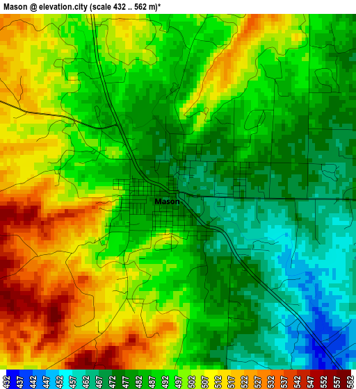
Below is the Elevation map of Mason, which displays elevation range with different colors. Scale of the first map is from 432 to 562 m (1417 to 1844 ft) with average elevation of 491.9 meters (=1614 ft) [note 1]
These maps also provides idea of topography and contour of this city, they are displayed at different zoom levels. More info about maps, scale and edge coordinates you can find below images.
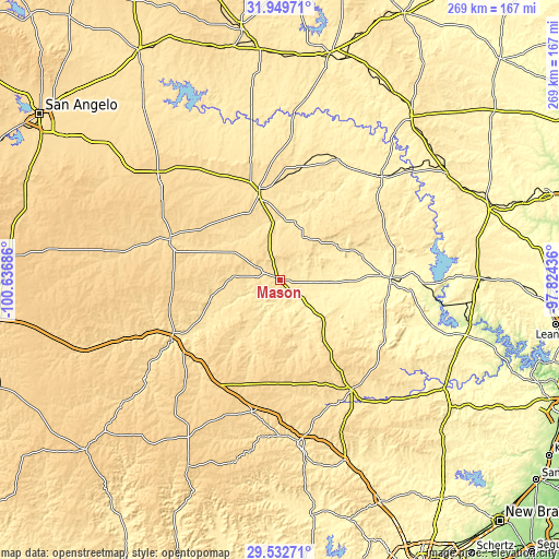
| \ | Map #1 | Topo.Map |
| Scale [m] | 432..562 m | × |
| Scale [ft] | 1417..1844 ft | × |
| Average | 491.9 m = 1614 ft | × |
| Width | 8.4 km = 5.2 mi | 268.7 km = 167 mi |
| Height | 8.4 km = 5.2 mi | 268.8 km = 167 mi |
| ↑Max Latitude | 30.78655° | 31.94971° |
| Latitude at center | 30.74879° | 30.74879° |
| ↓Min Latitude | 30.711015° | 29.53271° |
| ← Min Longitude | -99.274555° | -100.63686° |
| Longitude center | -99.23061° | -99.23061° |
| →Max Longitude | -99.186665° | -97.82436° |
Nearby cities:
Cities around Mason sort by population:
• Kerrville elevation 501 m
78.5 km,  173°
173°
• Fredericksburg 519 m
62.9 km,  146°
146°
• Kingsland 258 m
76.2 km,  97°
97°
• Brady 519 m
44.1 km,  346°
346°
• Llano 316 m
53.1 km,  88°
88°
• San Saba 373 m
69.7 km,  44°
44°
• Eden 626 m
78.4 km,  311°
311°
• Junction 522 m
59.3 km,  240°
240°
• Ingram 528 m
74.7 km,  180°
180°
• Buchanan Dam 324 m
76.4 km, 90°
• Menard 576 m
56.3 km,  289°
289°
• Harper 627 m
49.9 km, 181°
Multilingual:
 En español:
Mason elevación 472 m.
 En France:
Mason élévation 472 m.


Sources and notes:
- [note 1] Map square and city borders are not equal. Map elevation data is calculated only from area inside that square.
- [src 1] Elevation data from geonames database provided with same terms of usage.
- [src 2] The elevation map of Mason is generated using elevation data from NASA's 3 arcsec (90m) resolution SRTM data.
- [src 3] Base (background) map © OpenStreetMap contributors tiles are generated by Geofabrik and OpenTopoMap.
Copyright & License:
This Mason Elevation Map is licensed under CC BY-SA. You may reuse any part from this page, if you give a proper credit by linking to this URL:
 More info on terms of use page.