La Homa elevation
La Homa (Texas, Hidalgo County), United States elevation is 51 meters and La Homa elevation in feet is 167 ft above sea level [src 1]. La Homa is a populated place (feature code) with elevation that is 228 meters (748 ft) smaller than average city elevation in United States.
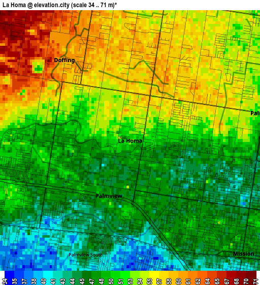
Below is the Elevation map of La Homa, which displays elevation range with different colors. Scale of the first map is from 34 to 71 m (112 to 233 ft) with average elevation of 51.1 meters (=168 ft) [note 1]
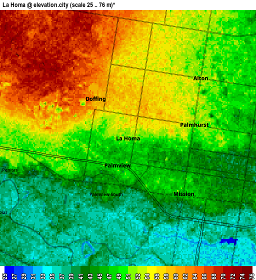
These maps also provides idea of topography and contour of this city, they are displayed at different zoom levels. More info about maps, scale and edge coordinates you can find below images.
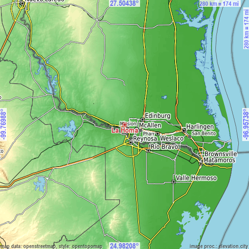
| \ | Map #1 | Map #2 | Topo.Map |
| Scale [m] | 34..71 m | 25..76 m | × |
| Scale [ft] | 112..233 ft | 82..249 ft | × |
| Average | 51.1 m = 168 ft | 49.6 m = 163 ft | × |
| Width | 8.76 km = 5.4 mi | 17.53 km = 10.9 mi | 280.5 km = 174.3 mi |
| Height | 8.76 km = 5.4 mi | 17.53 km = 10.9 mi | 280.5 km = 174.3 mi |
| ↑Max Latitude | 26.289477° | 26.32887° | 27.50438° |
| Latitude at center | 26.25007° | 26.25007° | 26.25007° |
| ↓Min Latitude | 26.21065° | 26.171217° | 24.98208° |
| ← Min Longitude | -98.407575° | -98.451521° | -99.76988° |
| Longitude center | -98.36363° | -98.36363° | -98.36363° |
| →Max Longitude | -98.319685° | -98.275739° | -96.95738° |
Nearby cities:
Cities around La Homa sort by population:
• Mission elevation 47 m
5.4 km,  134°
134°
• Alton 54 m
6.5 km,  50°
50°
• Palmview 49 m
2 km,  201°
201°
• Palmview South 44 m
4.1 km, 201°
• Alton North (historical) 50 m
7.8 km, 49°
• Perezville 41 m
4.7 km,  232°
232°
• Doffing 60 m
3.5 km,  320°
320°
• Penitas 48 m
8.4 km,  255°
255°
• Palmhurst 52 m
4.6 km,  78°
78°
• Citrus City 68 m
8.8 km,  345°
345°
• West Sharyland 53 m
4.3 km, 54°
• Abram 39 m
7.3 km,  220°
220°
Multilingual:
 En español:
La Homa elevación 51 m.
 En France:
La Homa élévation 51 m.


Sources and notes:
- [note 1] Map square and city borders are not equal. Map elevation data is calculated only from area inside that square.
- [src 1] Elevation data from geonames database provided with same terms of usage.
- [src 2] The elevation map of La Homa is generated using elevation data from NASA's 3 arcsec (90m) resolution SRTM data.
- [src 3] Base (background) map © OpenStreetMap contributors tiles are generated by Geofabrik and OpenTopoMap.
Copyright & License:
This La Homa Elevation Map is licensed under CC BY-SA. You may reuse any part from this page, if you give a proper credit by linking to this URL:
 More info on terms of use page.