Hawkins elevation
Hawkins (Texas, Wood County), United States elevation is 127 meters and Hawkins elevation in feet is 417 ft above sea level [src 1]. Hawkins is a populated place (feature code) with elevation that is 152 meters (499 ft) smaller than average city elevation in United States.
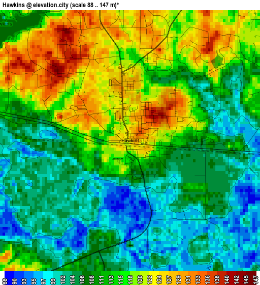
Below is the Elevation map of Hawkins, which displays elevation range with different colors. Scale of the first map is from 88 to 147 m (289 to 482 ft) with average elevation of 111.6 meters (=366 ft) [note 1]
These maps also provides idea of topography and contour of this city, they are displayed at different zoom levels. More info about maps, scale and edge coordinates you can find below images.
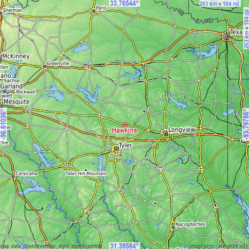
| \ | Map #1 | Topo.Map |
| Scale [m] | 88..147 m | × |
| Scale [ft] | 289..482 ft | × |
| Average | 111.6 m = 366 ft | × |
| Width | 8.23 km = 5.1 mi | 263.5 km = 163.7 mi |
| Height | 8.23 km = 5.1 mi | 263.5 km = 163.7 mi |
| ↑Max Latitude | 32.625489° | 33.76544° |
| Latitude at center | 32.58847° | 32.58847° |
| ↓Min Latitude | 32.551436° | 31.39584° |
| ← Min Longitude | -95.248055° | -96.61036° |
| Longitude center | -95.20411° | -95.20411° |
| →Max Longitude | -95.160165° | -93.79786° |
Nearby cities:
Cities around Hawkins sort by population:
• Tyler elevation 174 m
27.9 km,  199°
199°
• Kilgore 116 m
38.1 km,  126°
126°
• Gladewater 116 m
25.2 km,  103°
103°
• White Oak 128 m
32.8 km, 101°
• Lindale 174 m
20.9 km,  247°
247°
• Gilmer 117 m
29 km,  57°
57°
• Mineola 131 m
27.9 km,  287°
287°
• Hideaway 148 m
26.1 km, 245°
• Holly Lake Ranch 130 m
13.9 km,  2°
2°
• Liberty City 123 m
28.8 km,  123°
123°
• Quitman 128 m
32.7 km,  314°
314°
• Big Sandy 122 m
8.9 km,  93°
93°
Multilingual:
 En español:
Hawkins elevación 127 m.
 En France:
Hawkins élévation 127 m.


Sources and notes:
- [note 1] Map square and city borders are not equal. Map elevation data is calculated only from area inside that square.
- [src 1] Elevation data from geonames database provided with same terms of usage.
- [src 2] The elevation map of Hawkins is generated using elevation data from NASA's 3 arcsec (90m) resolution SRTM data.
- [src 3] Base (background) map © OpenStreetMap contributors tiles are generated by Geofabrik and OpenTopoMap.
Copyright & License:
This Hawkins Elevation Map is licensed under CC BY-SA. You may reuse any part from this page, if you give a proper credit by linking to this URL:
 More info on terms of use page.