Harlingen elevation
Harlingen (Texas, Cameron County), United States elevation is 17 meters and Harlingen elevation in feet is 56 ft above sea level [src 1]. Harlingen is a populated place (feature code) with elevation that is 262 meters (860 ft) smaller than average city elevation in United States.
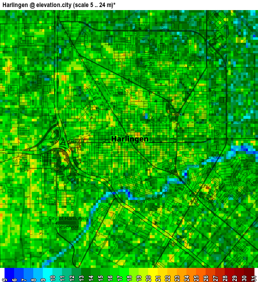
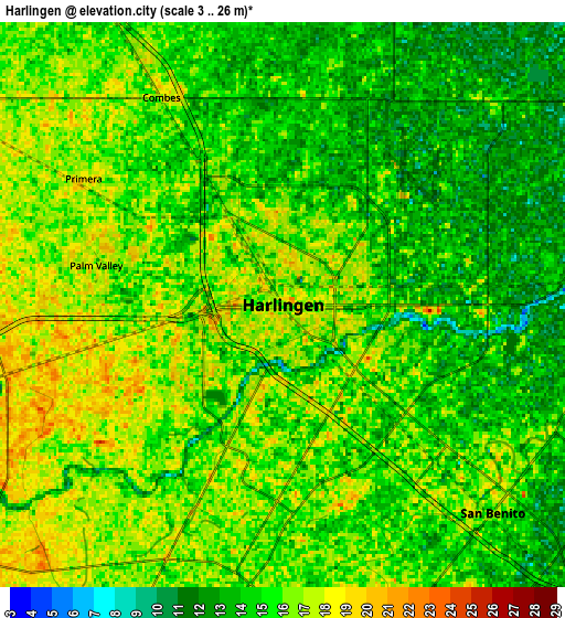
Below is the Elevation map of Harlingen, which displays elevation range with different colors. Scale of the first map is from 5 to 24 m (16 to 79 ft) with average elevation of 15.4 meters (=51 ft) [note 1]
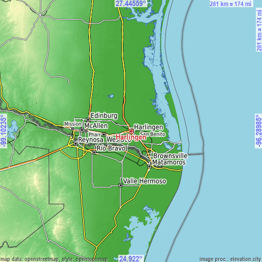
These maps also provides idea of topography and contour of this city, they are displayed at different zoom levels. More info about maps, scale and edge coordinates you can find below images.
| \ | Map #1 | Map #2 | Topo.Map |
| Scale [m] | 5..24 m | 3..26 m | × |
| Scale [ft] | 16..79 ft | 10..85 ft | × |
| Average | 15.4 m = 51 ft | 15 m = 49 ft | × |
| Width | 8.77 km = 5.4 mi | 17.54 km = 10.9 mi | 280.6 km = 174.4 mi |
| Height | 8.77 km = 5.4 mi | 17.54 km = 10.9 mi | 280.6 km = 174.4 mi |
| ↑Max Latitude | 26.230057° | 26.26947° | 27.44559° |
| Latitude at center | 26.19063° | 26.19063° | 26.19063° |
| ↓Min Latitude | 26.15119° | 26.111736° | 24.922° |
| ← Min Longitude | -97.740045° | -97.783991° | -99.10235° |
| Longitude center | -97.6961° | -97.6961° | -97.6961° |
| →Max Longitude | -97.652155° | -97.608209° | -96.28985° |
Nearby cities:
Cities around Harlingen sort by population:
• San Benito elevation 16 m
9.2 km,  134°
134°
• La Feria 21 m
13.2 km,  254°
254°
• Primera 18 m
7.3 km,  302°
302°
• Combes 16 m
7.5 km,  329°
329°
• La Paloma 20 m
16.3 km,  169°
169°
• Santa Rosa 20 m
14.8 km, 299°
• Rio Hondo 14 m
12.4 km,  66°
66°
• Heidelberg 23 m
18.4 km,  272°
272°
• Las Palmas II 14 m
4.3 km,  286°
286°
• Palm Valley 16 m
5.9 km,  282°
282°
• Green Valley Farms 8 m
15.5 km,  119°
119°
• Los Indios 22 m
16.5 km,  197°
197°
Multilingual:
 En español:
Harlingen elevación 17 m.
 En France:
Harlingen élévation 17 m.
 Auf Deutsch:
Harlingen höhe über dem Meeresspiegel ist 17 m.

Sources and notes:
- [note 1] Map square and city borders are not equal. Map elevation data is calculated only from area inside that square.
- [src 1] Elevation data from geonames database provided with same terms of usage.
- [src 2] The elevation map of Harlingen is generated using elevation data from NASA's 3 arcsec (90m) resolution SRTM data.
- [src 3] Base (background) map © OpenStreetMap contributors tiles are generated by Geofabrik and OpenTopoMap.
Copyright & License:
This Harlingen Elevation Map is licensed under CC BY-SA. You may reuse any part from this page, if you give a proper credit by linking to this URL:
 More info on terms of use page.