Goliad elevation
Goliad (Texas, Goliad County), United States elevation is 55 meters and Goliad elevation in feet is 180 ft above sea level [src 1]. Goliad is a seat of a second-order administrative division (feature code) with elevation that is 224 meters (735 ft) smaller than average city elevation in United States.
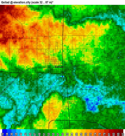
Below is the Elevation map of Goliad, which displays elevation range with different colors. Scale of the first map is from 32 to 87 m (105 to 285 ft) with average elevation of 56.5 meters (=185 ft) [note 1]
These maps also provides idea of topography and contour of this city, they are displayed at different zoom levels. More info about maps, scale and edge coordinates you can find below images.
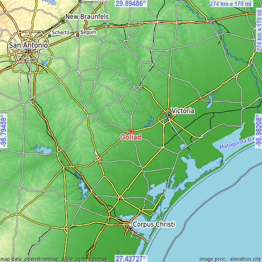
| \ | Map #1 | Topo.Map |
| Scale [m] | 32..87 m | × |
| Scale [ft] | 105..285 ft | × |
| Average | 56.5 m = 185 ft | × |
| Width | 8.57 km = 5.3 mi | 274.4 km = 170.5 mi |
| Height | 8.57 km = 5.3 mi | 274.4 km = 170.5 mi |
| ↑Max Latitude | 28.706881° | 29.89486° |
| Latitude at center | 28.66833° | 28.66833° |
| ↓Min Latitude | 28.629765° | 27.42727° |
| ← Min Longitude | -97.432275° | -98.79458° |
| Longitude center | -97.38833° | -97.38833° |
| →Max Longitude | -97.344385° | -95.98208° |
Nearby cities:
Cities around Goliad sort by population:
• Victoria elevation 35 m
40.5 km,  67°
67°
• Beeville 70 m
46.2 km,  229°
229°
• Cuero 60 m
48.3 km,  11°
11°
• Kenedy 85 m
47.9 km,  290°
290°
• Karnes City 133 m
55.5 km,  295°
295°
• Refugio 17 m
41.9 km,  164°
164°
• Bloomington 21 m
48.4 km,  92°
92°
• Yorktown 87 m
36.5 km,  342°
342°
• Inez 22 m
64.1 km, 65°
• Quail Creek 35 m
32.2 km, 68°
• Woodsboro 18 m
48.3 km,  172°
172°
• Runge 97 m
39.7 km,  307°
307°
Multilingual:
 En español:
Goliad elevación 55 m.
 En France:
Goliad élévation 55 m.


Sources and notes:
- [note 1] Map square and city borders are not equal. Map elevation data is calculated only from area inside that square.
- [src 1] Elevation data from geonames database provided with same terms of usage.
- [src 2] The elevation map of Goliad is generated using elevation data from NASA's 3 arcsec (90m) resolution SRTM data.
- [src 3] Base (background) map © OpenStreetMap contributors tiles are generated by Geofabrik and OpenTopoMap.
Copyright & License:
This Goliad Elevation Map is licensed under CC BY-SA. You may reuse any part from this page, if you give a proper credit by linking to this URL:
 More info on terms of use page.