Fort Worth elevation
Fort Worth (Texas, Tarrant County), United States elevation is 203 meters and Fort Worth elevation in feet is 666 ft above sea level [src 1]. Fort Worth is a seat of a second-order administrative division (feature code) with elevation that is 76 meters (249 ft) smaller than average city elevation in United States.
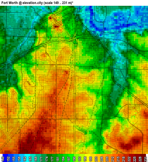
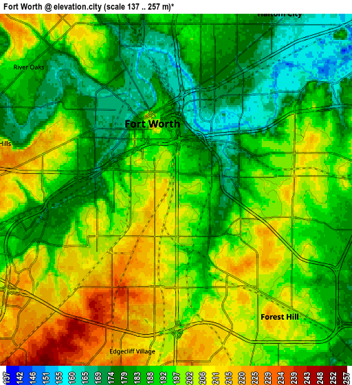
Below is the Elevation map of Fort Worth, which displays elevation range with different colors. Scale of the first map is from 149 to 231 m (489 to 758 ft) with average elevation of 190.9 meters (=626 ft) [note 1]
These maps also provides idea of topography and contour of this city, they are displayed at different zoom levels. More info about maps, scale and edge coordinates you can find below images.
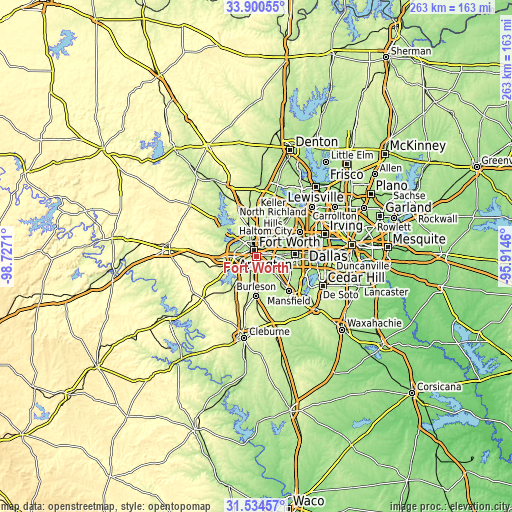
| \ | Map #1 | Map #2 | Topo.Map |
| Scale [m] | 149..231 m | 137..257 m | × |
| Scale [ft] | 489..758 ft | 449..843 ft | × |
| Average | 190.9 m = 626 ft | 193.5 m = 635 ft | × |
| Width | 8.22 km = 5.1 mi | 16.44 km = 10.2 mi | 263.1 km = 163.5 mi |
| Height | 8.22 km = 5.1 mi | 16.44 km = 10.2 mi | 263.1 km = 163.5 mi |
| ↑Max Latitude | 32.762372° | 32.799319° | 33.90055° |
| Latitude at center | 32.72541° | 32.72541° | 32.72541° |
| ↓Min Latitude | 32.688432° | 32.65144° | 31.53457° |
| ← Min Longitude | -97.364795° | -97.408741° | -98.7271° |
| Longitude center | -97.32085° | -97.32085° | -97.32085° |
| →Max Longitude | -97.276905° | -97.232959° | -95.9146° |
Nearby cities:
Cities around Fort Worth sort by population:
• Haltom City elevation 166 m
9.6 km,  30°
30°
• Benbrook 213 m
14.3 km,  246°
246°
• White Settlement 207 m
13.4 km,  286°
286°
• Forest Hill 215 m
7.7 km,  140°
140°
• Richland Hills 178 m
13.3 km,  40°
40°
• River Oaks 186 m
9 km,  309°
309°
• Kennedale 197 m
12.5 km,  134°
134°
• Everman 208 m
10.9 km,  164°
164°
• Sansom Park 236 m
11.8 km,  319°
319°
• Lake Worth 201 m
14.6 km, 307°
• Edgecliff Village 214 m
7.8 km,  195°
195°
• Westworth 179 m
9.1 km, 292°
Multilingual:
 En español:
Fort Worth elevación 203 m.
 En France:
Fort Worth élévation 203 m.
 Auf Deutsch:
Fort Worth höhe über dem Meeresspiegel ist 203 m.

Sources and notes:
- [note 1] Map square and city borders are not equal. Map elevation data is calculated only from area inside that square.
- [src 1] Elevation data from geonames database provided with same terms of usage.
- [src 2] The elevation map of Fort Worth is generated using elevation data from NASA's 3 arcsec (90m) resolution SRTM data.
- [src 3] Base (background) map © OpenStreetMap contributors tiles are generated by Geofabrik and OpenTopoMap.
Copyright & License:
This Fort Worth Elevation Map is licensed under CC BY-SA. You may reuse any part from this page, if you give a proper credit by linking to this URL:
 More info on terms of use page.