Elkhart elevation
Elkhart (Texas, Anderson County), United States elevation is 122 meters and Elkhart elevation in feet is 400 ft above sea level [src 1]. Elkhart is a populated place (feature code) with elevation that is 157 meters (515 ft) smaller than average city elevation in United States.
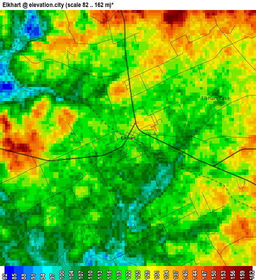
Below is the Elevation map of Elkhart, which displays elevation range with different colors. Scale of the first map is from 82 to 162 m (269 to 531 ft) with average elevation of 120.9 meters (=397 ft) [note 1]
These maps also provides idea of topography and contour of this city, they are displayed at different zoom levels. More info about maps, scale and edge coordinates you can find below images.
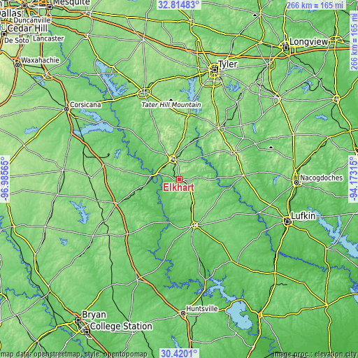
| \ | Map #1 | Topo.Map |
| Scale [m] | 82..162 m | × |
| Scale [ft] | 269..531 ft | × |
| Average | 120.9 m = 397 ft | × |
| Width | 8.32 km = 5.2 mi | 266.3 km = 165.5 mi |
| Height | 8.32 km = 5.2 mi | 266.3 km = 165.5 mi |
| ↑Max Latitude | 31.662582° | 32.81483° |
| Latitude at center | 31.62517° | 31.62517° |
| ↓Min Latitude | 31.587743° | 30.4201° |
| ← Min Longitude | -95.623345° | -96.98565° |
| Longitude center | -95.5794° | -95.5794° |
| →Max Longitude | -95.535455° | -94.17315° |
Nearby cities:
Cities around Elkhart sort by population:
• Palestine elevation 150 m
16 km,  342°
342°
• Jacksonville 160 m
47.6 km,  37°
37°
• Crockett 116 m
36.1 km,  161°
161°
• Rusk 164 m
44.8 km,  64°
64°
• Hickory Creek 126 m
36.7 km,  138°
138°
• Cooper 81 m
42.5 km,  180°
180°
• Buffalo 120 m
48.8 km,  248°
248°
• Grapeland 149 m
17.6 km,  147°
147°
• Alto 136 m
48 km,  86°
86°
• Frankston 133 m
48 km,  8°
8°
• Berryville 121 m
52.5 km, 11°
• Centerville 109 m
55.7 km,  222°
222°
Multilingual:
 En español:
Elkhart elevación 122 m.
 En France:
Elkhart élévation 122 m.


Sources and notes:
- [note 1] Map square and city borders are not equal. Map elevation data is calculated only from area inside that square.
- [src 1] Elevation data from geonames database provided with same terms of usage.
- [src 2] The elevation map of Elkhart is generated using elevation data from NASA's 3 arcsec (90m) resolution SRTM data.
- [src 3] Base (background) map © OpenStreetMap contributors tiles are generated by Geofabrik and OpenTopoMap.
Copyright & License:
This Elkhart Elevation Map is licensed under CC BY-SA. You may reuse any part from this page, if you give a proper credit by linking to this URL:
 More info on terms of use page.