Carthage elevation
Carthage (Texas, Panola County), United States elevation is 99 meters and Carthage elevation in feet is 325 ft above sea level [src 1]. Carthage is a seat of a second-order administrative division (feature code) with elevation that is 180 meters (591 ft) smaller than average city elevation in United States.
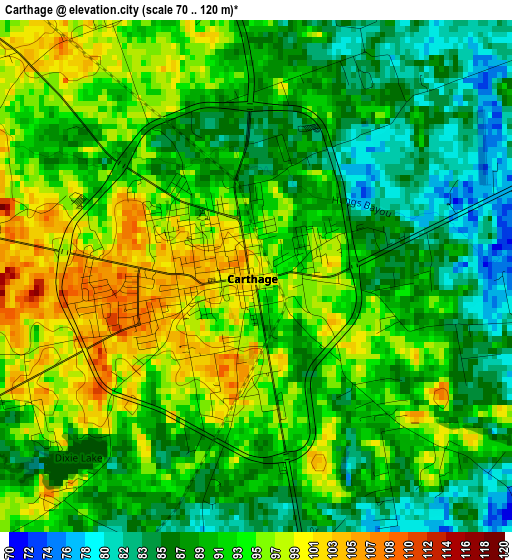
Below is the Elevation map of Carthage, which displays elevation range with different colors. Scale of the first map is from 70 to 120 m (230 to 394 ft) with average elevation of 91.5 meters (=300 ft) [note 1]
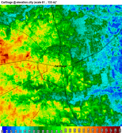
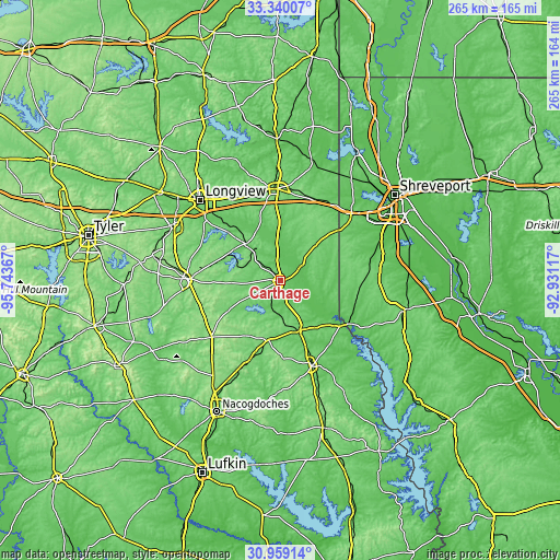
These maps also provides idea of topography and contour of this city, they are displayed at different zoom levels. More info about maps, scale and edge coordinates you can find below images.
| \ | Map #1 | Map #2 | Topo.Map |
| Scale [m] | 70..120 m | 61..133 m | × |
| Scale [ft] | 230..394 ft | 200..436 ft | × |
| Average | 91.5 m = 300 ft | 89.3 m = 293 ft | × |
| Width | 8.27 km = 5.1 mi | 16.55 km = 10.3 mi | 264.7 km = 164.5 mi |
| Height | 8.27 km = 5.1 mi | 16.55 km = 10.3 mi | 264.7 km = 164.5 mi |
| ↑Max Latitude | 32.194576° | 32.231757° | 33.34007° |
| Latitude at center | 32.15738° | 32.15738° | 32.15738° |
| ↓Min Latitude | 32.120169° | 32.082942° | 30.95914° |
| ← Min Longitude | -94.381365° | -94.425311° | -95.74367° |
| Longitude center | -94.33742° | -94.33742° | -94.33742° |
| →Max Longitude | -94.293475° | -94.249529° | -92.93117° |
Nearby cities:
Cities around Carthage sort by population:
• Longview elevation 119 m
53.8 km,  315°
315°
• Marshall 129 m
43.2 km,  356°
356°
• Henderson 160 m
43.5 km,  269°
269°
• Center 118 m
42.9 km,  159°
159°
• Hallsville 114 m
44.5 km,  330°
330°
• Greenwood 81 m
46.7 km,  47°
47°
• Waskom 89 m
44.3 km,  36°
36°
• Stonewall 74 m
50.2 km,  74°
74°
• Logansport 71 m
37.8 km,  122°
122°
• Tatum 107 m
24.4 km, 316°
• Tenaha 111 m
25.3 km, 159°
• Timpson 122 m
28.7 km,  190°
190°
Multilingual:
 En español:
Carthage elevación 99 m.
 En France:
Carthage élévation 99 m.


Sources and notes:
- [note 1] Map square and city borders are not equal. Map elevation data is calculated only from area inside that square.
- [src 1] Elevation data from geonames database provided with same terms of usage.
- [src 2] The elevation map of Carthage is generated using elevation data from NASA's 3 arcsec (90m) resolution SRTM data.
- [src 3] Base (background) map © OpenStreetMap contributors tiles are generated by Geofabrik and OpenTopoMap.
Copyright & License:
This Carthage Elevation Map is licensed under CC BY-SA. You may reuse any part from this page, if you give a proper credit by linking to this URL:
 More info on terms of use page.