Benavides elevation
Benavides (Texas, Duval County), United States elevation is 120 meters and Benavides elevation in feet is 394 ft above sea level [src 1]. Benavides is a populated place (feature code) with elevation that is 159 meters (522 ft) smaller than average city elevation in United States.
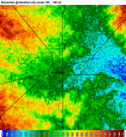
Below is the Elevation map of Benavides, which displays elevation range with different colors. Scale of the first map is from 104 to 146 m (341 to 479 ft) with average elevation of 123 meters (=404 ft) [note 1]
These maps also provides idea of topography and contour of this city, they are displayed at different zoom levels. More info about maps, scale and edge coordinates you can find below images.
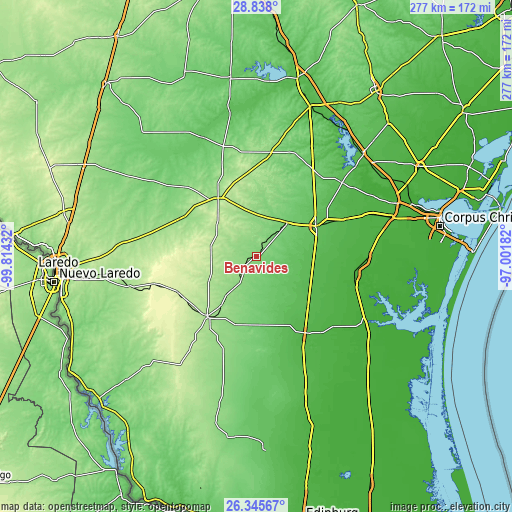
| \ | Map #1 | Topo.Map |
| Scale [m] | 104..146 m | × |
| Scale [ft] | 341..479 ft | × |
| Average | 123 m = 404 ft | × |
| Width | 8.66 km = 5.4 mi | 277.1 km = 172.2 mi |
| Height | 8.66 km = 5.4 mi | 277.1 km = 172.2 mi |
| ↑Max Latitude | 27.637858° | 28.838° |
| Latitude at center | 27.59892° | 27.59892° |
| ↓Min Latitude | 27.559968° | 26.34567° |
| ← Min Longitude | -98.452015° | -99.81432° |
| Longitude center | -98.40807° | -98.40807° |
| →Max Longitude | -98.364125° | -97.00182° |
Nearby cities:
Cities around Benavides sort by population:
• Kingsville elevation 21 m
55.2 km,  99°
99°
• Alice 70 m
37.4 km,  62°
62°
• Falfurrias 41 m
48.9 km,  147°
147°
• Hebbronville 174 m
42.1 km,  219°
219°
• San Diego 96 m
24.8 km,  42°
42°
• Bishop 22 m
60 km,  91°
91°
• Freer 160 m
37.7 km,  326°
326°
• Premont 55 m
38.6 km,  133°
133°
• Rancho Alegre 72 m
34.7 km, 62°
• Orange Grove 62 m
61.1 km,  49°
49°
• Ricardo 22 m
58.4 km,  109°
109°
• Sarita 13 m
74.1 km,  124°
124°
Multilingual:
 En español:
Benavides elevación 120 m.
 En France:
Benavides élévation 120 m.
 Auf Deutsch:
Benavides höhe über dem Meeresspiegel ist 120 m.

Sources and notes:
- [note 1] Map square and city borders are not equal. Map elevation data is calculated only from area inside that square.
- [src 1] Elevation data from geonames database provided with same terms of usage.
- [src 2] The elevation map of Benavides is generated using elevation data from NASA's 3 arcsec (90m) resolution SRTM data.
- [src 3] Base (background) map © OpenStreetMap contributors tiles are generated by Geofabrik and OpenTopoMap.
Copyright & License:
This Benavides Elevation Map is licensed under CC BY-SA. You may reuse any part from this page, if you give a proper credit by linking to this URL:
 More info on terms of use page.