Louisville elevation
Louisville (Tennessee, Blount County), United States elevation is 256 meters and Louisville elevation in feet is 840 ft above sea level [src 1]. Louisville is a populated place (feature code) with elevation that is 23 meters (75 ft) smaller than average city elevation in United States.
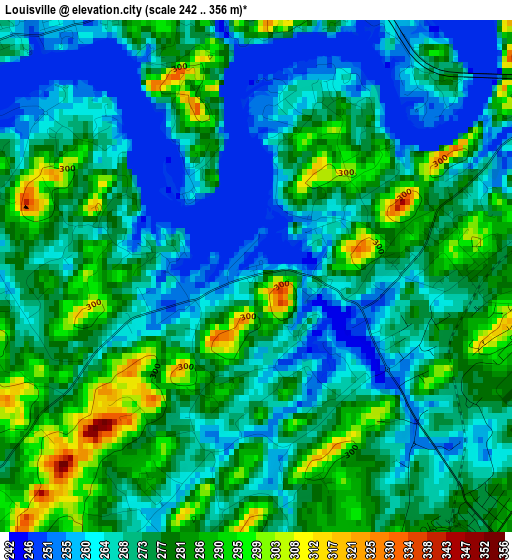
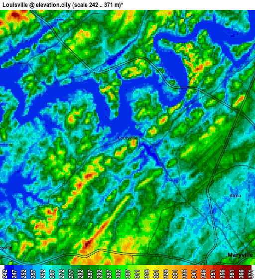
Below is the Elevation map of Louisville, which displays elevation range with different colors. Scale of the first map is from 242 to 356 m (794 to 1168 ft) with average elevation of 273.6 meters (=898 ft) [note 1]
These maps also provides idea of topography and contour of this city, they are displayed at different zoom levels. More info about maps, scale and edge coordinates you can find below images.
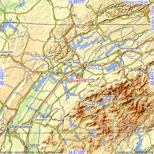
| \ | Map #1 | Map #2 | Topo.Map |
| Scale [m] | 242..356 m | 242..371 m | × |
| Scale [ft] | 794..1168 ft | 794..1217 ft | × |
| Average | 273.6 m = 898 ft | 277.5 m = 910 ft | × |
| Width | 7.92 km = 4.9 mi | 15.85 km = 9.8 mi | 253.6 km = 157.6 mi |
| Height | 7.92 km = 4.9 mi | 15.85 km = 9.8 mi | 253.6 km = 157.6 mi |
| ↑Max Latitude | 35.857375° | 35.892983° | 36.95377° |
| Latitude at center | 35.82175° | 35.82175° | 35.82175° |
| ↓Min Latitude | 35.786109° | 35.750453° | 34.67335° |
| ← Min Longitude | -84.091905° | -84.135851° | -85.45421° |
| Longitude center | -84.04796° | -84.04796° | -84.04796° |
| →Max Longitude | -84.004015° | -83.960069° | -82.64171° |
Nearby cities:
Cities around Louisville sort by population:
• Knoxville elevation 277 m
19.2 km,  36°
36°
• Oak Ridge 259 m
29 km,  316°
316°
• Maryville 286 m
10.1 km,  136°
136°
• Farragut 266 m
11.8 km,  306°
306°
• Seymour 289 m
30.1 km,  75°
75°
• Alcoa 258 m
7.6 km,  118°
118°
• Lenoir City 252 m
19 km,  261°
261°
• Tellico Village 268 m
24.2 km,  230°
230°
• Loudon 252 m
27.6 km,  249°
249°
• Eagleton Village 297 m
10.9 km,  105°
105°
• Greenback 271 m
21.1 km,  212°
212°
• Wildwood 287 m
16.1 km,  97°
97°
Multilingual:
 En español:
Louisville elevación 256 m.
 En France:
Louisville élévation 256 m.
 Auf Deutsch:
Louisville höhe über dem Meeresspiegel ist 256 m.

Sources and notes:
- [note 1] Map square and city borders are not equal. Map elevation data is calculated only from area inside that square.
- [src 1] Elevation data from geonames database provided with same terms of usage.
- [src 2] The elevation map of Louisville is generated using elevation data from NASA's 3 arcsec (90m) resolution SRTM data.
- [src 3] Base (background) map © OpenStreetMap contributors tiles are generated by Geofabrik and OpenTopoMap.
Copyright & License:
This Louisville Elevation Map is licensed under CC BY-SA. You may reuse any part from this page, if you give a proper credit by linking to this URL:
 More info on terms of use page.