Huntingdon elevation
Huntingdon (Tennessee, Carroll County), United States elevation is 123 meters and Huntingdon elevation in feet is 404 ft above sea level [src 1]. Huntingdon is a seat of a second-order administrative division (feature code) with elevation that is 156 meters (512 ft) smaller than average city elevation in United States.
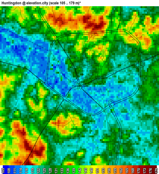
Below is the Elevation map of Huntingdon, which displays elevation range with different colors. Scale of the first map is from 105 to 179 m (344 to 587 ft) with average elevation of 131 meters (=430 ft) [note 1]
These maps also provides idea of topography and contour of this city, they are displayed at different zoom levels. More info about maps, scale and edge coordinates you can find below images.
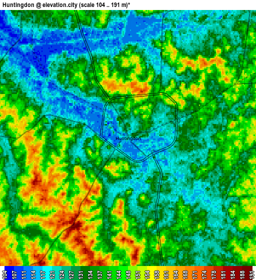
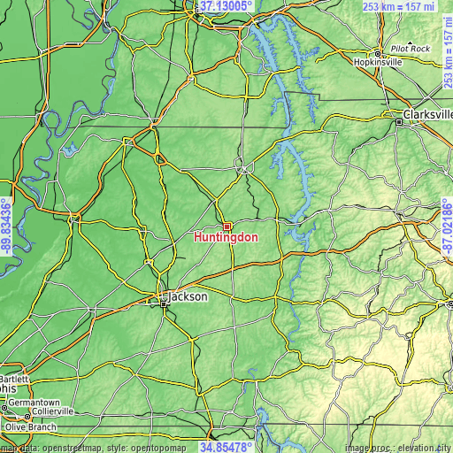
| \ | Map #1 | Map #2 | Topo.Map |
| Scale [m] | 105..179 m | 104..191 m | × |
| Scale [ft] | 344..587 ft | 341..627 ft | × |
| Average | 131 m = 430 ft | 135.3 m = 444 ft | × |
| Width | 7.91 km = 4.9 mi | 15.81 km = 9.8 mi | 253 km = 157.2 mi |
| Height | 7.91 km = 4.9 mi | 15.81 km = 9.8 mi | 253 km = 157.2 mi |
| ↑Max Latitude | 36.036164° | 36.071692° | 37.13005° |
| Latitude at center | 36.00062° | 36.00062° | 36.00062° |
| ↓Min Latitude | 35.96506° | 35.929484° | 34.85478° |
| ← Min Longitude | -88.472055° | -88.516001° | -89.83436° |
| Longitude center | -88.42811° | -88.42811° | -88.42811° |
| →Max Longitude | -88.384165° | -88.340219° | -87.02186° |
Nearby cities:
Cities around Huntingdon sort by population:
• Paris elevation 158 m
34.7 km,  15°
15°
• Lexington 161 m
39 km,  175°
175°
• Milan 128 m
31.1 km,  253°
253°
• McKenzie 150 m
16.8 km,  330°
330°
• Medina 149 m
38.2 km,  234°
234°
• Camden 141 m
30.4 km,  77°
77°
• Dresden 132 m
41 km,  322°
322°
• Greenfield 136 m
37.5 km,  296°
296°
• New Johnsonville 131 m
41.5 km,  86°
86°
• Bruceton 144 m
17 km, 75°
• Gleason 128 m
28.9 km, 325°
• Bradford 112 m
35.4 km,  283°
283°
Multilingual:
 En español:
Huntingdon elevación 123 m.
 En France:
Huntingdon élévation 123 m.
 Auf Deutsch:
Huntingdon höhe über dem Meeresspiegel ist 123 m.

Sources and notes:
- [note 1] Map square and city borders are not equal. Map elevation data is calculated only from area inside that square.
- [src 1] Elevation data from geonames database provided with same terms of usage.
- [src 2] The elevation map of Huntingdon is generated using elevation data from NASA's 3 arcsec (90m) resolution SRTM data.
- [src 3] Base (background) map © OpenStreetMap contributors tiles are generated by Geofabrik and OpenTopoMap.
Copyright & License:
This Huntingdon Elevation Map is licensed under CC BY-SA. You may reuse any part from this page, if you give a proper credit by linking to this URL:
 More info on terms of use page.