Brentwood elevation
Brentwood (Tennessee, Williamson County), United States elevation is 231 meters and Brentwood elevation in feet is 758 ft above sea level [src 1]. Brentwood is a populated place (feature code) with elevation that is 48 meters (157 ft) smaller than average city elevation in United States.
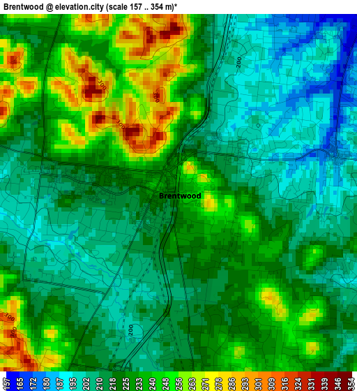
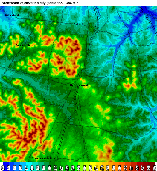
Below is the Elevation map of Brentwood, which displays elevation range with different colors. Scale of the first map is from 157 to 354 m (515 to 1161 ft) with average elevation of 224.6 meters (=737 ft) [note 1]
These maps also provides idea of topography and contour of this city, they are displayed at different zoom levels. More info about maps, scale and edge coordinates you can find below images.
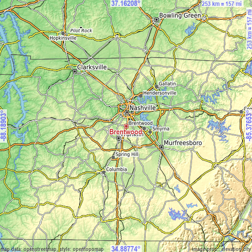
| \ | Map #1 | Map #2 | Topo.Map |
| Scale [m] | 157..354 m | 138..354 m | × |
| Scale [ft] | 515..1161 ft | 453..1161 ft | × |
| Average | 224.6 m = 737 ft | 218.5 m = 717 ft | × |
| Width | 7.9 km = 4.9 mi | 15.81 km = 9.8 mi | 252.9 km = 157.1 mi |
| Height | 7.9 km = 4.9 mi | 15.81 km = 9.8 mi | 252.9 km = 157.1 mi |
| ↑Max Latitude | 36.06865° | 36.104163° | 37.16208° |
| Latitude at center | 36.03312° | 36.03312° | 36.03312° |
| ↓Min Latitude | 35.997574° | 35.962013° | 34.88774° |
| ← Min Longitude | -86.826725° | -86.870671° | -88.18903° |
| Longitude center | -86.78278° | -86.78278° | -86.78278° |
| →Max Longitude | -86.738835° | -86.694889° | -85.37653° |
Nearby cities:
Cities around Brentwood sort by population:
• Nashville elevation 171 m
14.8 km,  359°
359°
• Franklin 201 m
14.3 km,  212°
212°
• Smyrna 167 m
24.4 km,  103°
103°
• La Vergne 179 m
18.2 km, 96°
• Brentwood Estates 227 m
1 km,  160°
160°
• Nolensville 189 m
13.6 km,  131°
131°
• Forest Hills 203 m
6.8 km,  305°
305°
• Oak Hill 185 m
6.1 km, 359°
• Thompson's Station 249 m
28.2 km,  204°
204°
• Belle Meade 174 m
9.7 km,  316°
316°
• Lakewood 143 m
26.8 km,  29°
29°
• Pegram 170 m
25.3 km,  287°
287°
Multilingual:
 En español:
Brentwood elevación 231 m.
 En France:
Brentwood élévation 231 m.
 Auf Deutsch:
Brentwood höhe über dem Meeresspiegel ist 231 m.

Sources and notes:
- [note 1] Map square and city borders are not equal. Map elevation data is calculated only from area inside that square.
- [src 1] Elevation data from geonames database provided with same terms of usage.
- [src 2] The elevation map of Brentwood is generated using elevation data from NASA's 3 arcsec (90m) resolution SRTM data.
- [src 3] Base (background) map © OpenStreetMap contributors tiles are generated by Geofabrik and OpenTopoMap.
Copyright & License:
This Brentwood Elevation Map is licensed under CC BY-SA. You may reuse any part from this page, if you give a proper credit by linking to this URL:
 More info on terms of use page.