Saint Matthews elevation
Saint Matthews (South Carolina, Calhoun County), United States elevation is 87 meters and Saint Matthews elevation in feet is 285 ft above sea level [src 1]. Saint Matthews is a seat of a second-order administrative division (feature code) with elevation that is 192 meters (630 ft) smaller than average city elevation in United States.
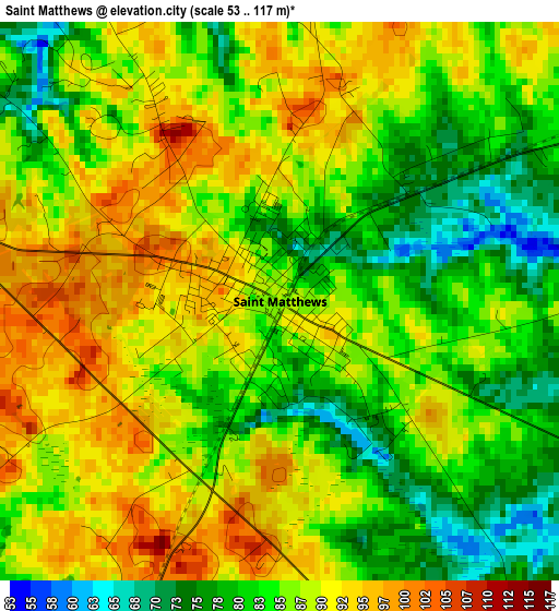
Below is the Elevation map of Saint Matthews, which displays elevation range with different colors. Scale of the first map is from 53 to 117 m (174 to 384 ft) with average elevation of 86.3 meters (=283 ft) [note 1]
These maps also provides idea of topography and contour of this city, they are displayed at different zoom levels. More info about maps, scale and edge coordinates you can find below images.
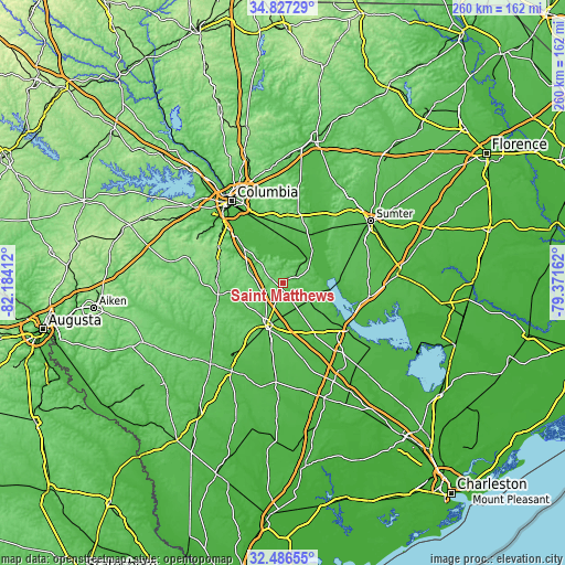
| \ | Map #1 | Topo.Map |
| Scale [m] | 53..117 m | × |
| Scale [ft] | 174..384 ft | × |
| Average | 86.3 m = 283 ft | × |
| Width | 8.13 km = 5.1 mi | 260.3 km = 161.7 mi |
| Height | 8.13 km = 5.1 mi | 260.3 km = 161.7 mi |
| ↑Max Latitude | 33.701448° | 34.82729° |
| Latitude at center | 33.66488° | 33.66488° |
| ↓Min Latitude | 33.628297° | 32.48655° |
| ← Min Longitude | -80.821815° | -82.18412° |
| Longitude center | -80.77787° | -80.77787° |
| →Max Longitude | -80.733925° | -79.37162° |
Nearby cities:
Cities around Saint Matthews sort by population:
• Orangeburg elevation 76 m
20.5 km,  200°
200°
• Oak Grove 107 m
21.5 km,  305°
305°
• Brookdale 70 m
18.1 km,  193°
193°
• Hopkins 53 m
28.2 km,  341°
341°
• Edisto 68 m
23.7 km,  208°
208°
• Wilkinson Heights 75 m
18.8 km, 195°
• Privateer 57 m
38.5 km,  60°
60°
• Gaston 151 m
34.3 km,  299°
299°
• Gadsden 49 m
20.1 km,  3°
3°
• Wedgewood 62 m
34.5 km,  45°
45°
• Wedgefield 77 m
34.9 km,  43°
43°
• Stateburg 96 m
39.5 km,  34°
34°
Multilingual:
 En español:
Saint Matthews elevación 87 m.
 En France:
Saint Matthews élévation 87 m.
 Auf Deutsch:
Saint Matthews höhe über dem Meeresspiegel ist 87 m.

Sources and notes:
- [note 1] Map square and city borders are not equal. Map elevation data is calculated only from area inside that square.
- [src 1] Elevation data from geonames database provided with same terms of usage.
- [src 2] The elevation map of Saint Matthews is generated using elevation data from NASA's 3 arcsec (90m) resolution SRTM data.
- [src 3] Base (background) map © OpenStreetMap contributors tiles are generated by Geofabrik and OpenTopoMap.
Copyright & License:
This Saint Matthews Elevation Map is licensed under CC BY-SA. You may reuse any part from this page, if you give a proper credit by linking to this URL:
 More info on terms of use page.