Pickens elevation
Pickens (South Carolina, Pickens County), United States elevation is 338 meters and Pickens elevation in feet is 1109 ft above sea level [src 1]. Pickens is a seat of a second-order administrative division (feature code) with elevation that is 59 meters (194 ft) bigger than average city elevation in United States.
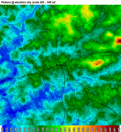
Below is the Elevation map of Pickens, which displays elevation range with different colors. Scale of the first map is from 265 to 448 m (869 to 1470 ft) with average elevation of 315.3 meters (=1034 ft) [note 1]
These maps also provides idea of topography and contour of this city, they are displayed at different zoom levels. More info about maps, scale and edge coordinates you can find below images.
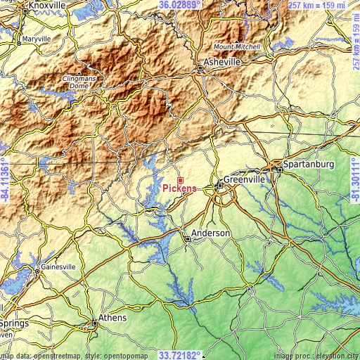
| \ | Map #1 | Topo.Map |
| Scale [m] | 265..448 m | × |
| Scale [ft] | 869..1470 ft | × |
| Average | 315.3 m = 1034 ft | × |
| Width | 8.02 km = 5 mi | 256.5 km = 159.4 mi |
| Height | 8.02 km = 5 mi | 256.5 km = 159.4 mi |
| ↑Max Latitude | 34.919491° | 36.02889° |
| Latitude at center | 34.88345° | 34.88345° |
| ↓Min Latitude | 34.847393° | 33.72182° |
| ← Min Longitude | -82.751305° | -84.11361° |
| Longitude center | -82.70736° | -82.70736° |
| →Max Longitude | -82.663415° | -81.30111° |
Nearby cities:
Cities around Pickens sort by population:
• Easley elevation 328 m
11.3 km,  121°
121°
• Clemson 222 m
25.2 km,  208°
208°
• Berea 318 m
22.9 km,  89°
89°
• Parker 309 m
23.4 km,  98°
98°
• Powdersville 296 m
22.1 km, 117°
• Welcome 301 m
25.3 km, 104°
• Central 278 m
18.9 km,  200°
200°
• Travelers Rest 336 m
25.8 km,  68°
68°
• Liberty 301 m
10.7 km,  172°
172°
• Arial 335 m
7.3 km, 124°
• Slater-Marietta 331 m
25.8 km,  49°
49°
• City View 301 m
25.3 km, 95°
Multilingual:
 En español:
Pickens elevación 338 m.
 En France:
Pickens élévation 338 m.


Sources and notes:
- [note 1] Map square and city borders are not equal. Map elevation data is calculated only from area inside that square.
- [src 1] Elevation data from geonames database provided with same terms of usage.
- [src 2] The elevation map of Pickens is generated using elevation data from NASA's 3 arcsec (90m) resolution SRTM data.
- [src 3] Base (background) map © OpenStreetMap contributors tiles are generated by Geofabrik and OpenTopoMap.
Copyright & License:
This Pickens Elevation Map is licensed under CC BY-SA. You may reuse any part from this page, if you give a proper credit by linking to this URL:
 More info on terms of use page.