Abbeville elevation
Abbeville (South Carolina, Abbeville County), United States elevation is 186 meters and Abbeville elevation in feet is 610 ft above sea level [src 1]. Abbeville is a seat of a second-order administrative division (feature code) with elevation that is 93 meters (305 ft) smaller than average city elevation in United States.
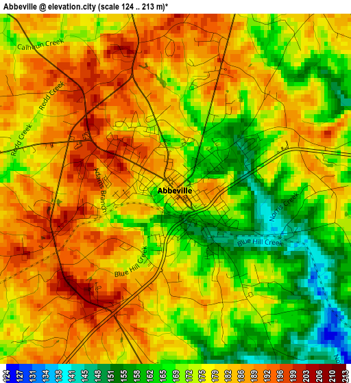
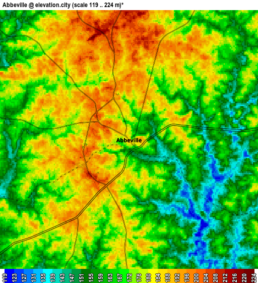
Below is the Elevation map of Abbeville, which displays elevation range with different colors. Scale of the first map is from 124 to 213 m (407 to 699 ft) with average elevation of 177.2 meters (=581 ft) [note 1]
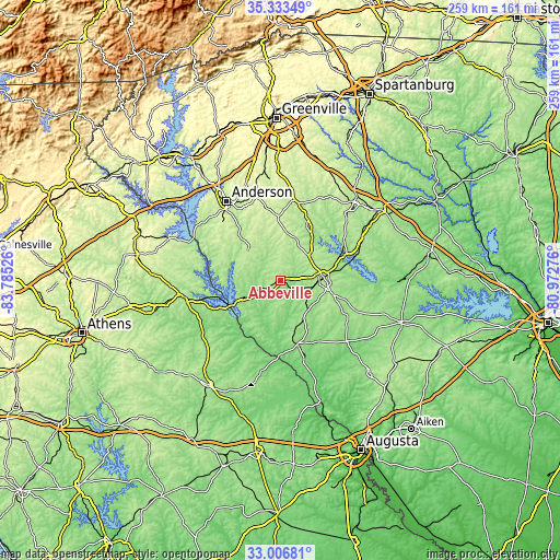
These maps also provides idea of topography and contour of this city, they are displayed at different zoom levels. More info about maps, scale and edge coordinates you can find below images.
| \ | Map #1 | Map #2 | Topo.Map |
| Scale [m] | 124..213 m | 119..224 m | × |
| Scale [ft] | 407..699 ft | 390..735 ft | × |
| Average | 177.2 m = 581 ft | 171.4 m = 562 ft | × |
| Width | 8.08 km = 5 mi | 16.17 km = 10 mi | 258.7 km = 160.7 mi |
| Height | 8.08 km = 5 mi | 16.17 km = 10 mi | 258.7 km = 160.7 mi |
| ↑Max Latitude | 34.214518° | 34.25085° | 35.33349° |
| Latitude at center | 34.17817° | 34.17817° | 34.17817° |
| ↓Min Latitude | 34.141806° | 34.105427° | 33.00681° |
| ← Min Longitude | -82.422955° | -82.466901° | -83.78526° |
| Longitude center | -82.37901° | -82.37901° | -82.37901° |
| →Max Longitude | -82.335065° | -82.291119° | -80.97276° |
Nearby cities:
Cities around Abbeville sort by population:
• Greenwood elevation 205 m
20.1 km,  84°
84°
• Homeland Park 241 m
42.1 km,  320°
320°
• Belton 269 m
39.8 km,  344°
344°
• Honea Path 242 m
29.9 km,  357°
357°
• McCormick 166 m
30.5 km,  165°
165°
• Ware Shoals 197 m
27.3 km,  26°
26°
• Ninety Six 167 m
32.7 km,  90°
90°
• Calhoun Falls 161 m
22.1 km,  244°
244°
• Lincolnton 147 m
43.9 km,  192°
192°
• Iva 221 m
29.8 km,  298°
298°
• Due West 216 m
17.3 km, 357°
• Lake Secession 175 m
23.1 km, 300°
Multilingual:
 En español:
Abbeville elevación 186 m.
 En France:
Abbeville élévation 186 m.
 Auf Deutsch:
Abbeville höhe über dem Meeresspiegel ist 186 m.

Sources and notes:
- [note 1] Map square and city borders are not equal. Map elevation data is calculated only from area inside that square.
- [src 1] Elevation data from geonames database provided with same terms of usage.
- [src 2] The elevation map of Abbeville is generated using elevation data from NASA's 3 arcsec (90m) resolution SRTM data.
- [src 3] Base (background) map © OpenStreetMap contributors tiles are generated by Geofabrik and OpenTopoMap.
Copyright & License:
This Abbeville Elevation Map is licensed under CC BY-SA. You may reuse any part from this page, if you give a proper credit by linking to this URL:
 More info on terms of use page.