York elevation
York (Pennsylvania, York County), United States elevation is 123 meters and York elevation in feet is 404 ft above sea level [src 1]. York is a seat of a second-order administrative division (feature code) with elevation that is 156 meters (512 ft) smaller than average city elevation in United States.
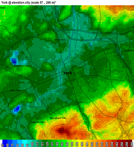
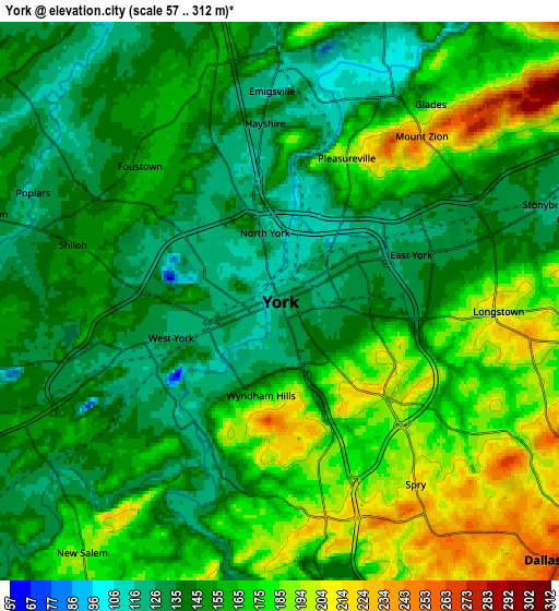
Below is the Elevation map of York, which displays elevation range with different colors. Scale of the first map is from 57 to 266 m (187 to 873 ft) with average elevation of 141.4 meters (=464 ft) [note 1]
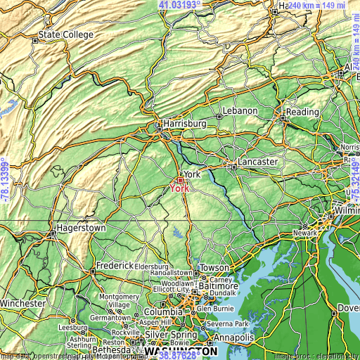
These maps also provides idea of topography and contour of this city, they are displayed at different zoom levels. More info about maps, scale and edge coordinates you can find below images.
| \ | Map #1 | Map #2 | Topo.Map |
| Scale [m] | 57..266 m | 57..312 m | × |
| Scale [ft] | 187..873 ft | 187..1024 ft | × |
| Average | 141.4 m = 464 ft | 157.6 m = 517 ft | × |
| Width | 7.49 km = 4.7 mi | 14.98 km = 9.3 mi | 239.7 km = 148.9 mi |
| Height | 7.49 km = 4.7 mi | 14.98 km = 9.3 mi | 239.7 km = 148.9 mi |
| ↑Max Latitude | 39.996274° | 40.029932° | 41.03193° |
| Latitude at center | 39.9626° | 39.9626° | 39.9626° |
| ↓Min Latitude | 39.928909° | 39.895202° | 38.87628° |
| ← Min Longitude | -76.771685° | -76.815631° | -78.13399° |
| Longitude center | -76.72774° | -76.72774° | -76.72774° |
| →Max Longitude | -76.683795° | -76.639849° | -75.32149° |
Nearby cities:
Cities around York sort by population:
• Weigelstown elevation 155 m
8.4 km,  286°
286°
• Shiloh 140 m
6.2 km, 286°
• East York 129 m
3.7 km,  70°
70°
• Spry 218 m
6.1 km,  143°
143°
• West York 119 m
2.3 km,  241°
241°
• Grantley 180 m
2.5 km,  182°
182°
• Valley View 187 m
2.7 km,  121°
121°
• Emigsville 131 m
6.6 km,  359°
359°
• Stonybrook 123 m
7.6 km, 69°
• North York 122 m
1.8 km,  345°
345°
• Yorklyn 134 m
7.7 km,  64°
64°
• Jacobus 205 m
9 km,  170°
170°
Multilingual:
 En español:
York elevación 123 m.
 En France:
York élévation 123 m.


Sources and notes:
- [note 1] Map square and city borders are not equal. Map elevation data is calculated only from area inside that square.
- [src 1] Elevation data from geonames database provided with same terms of usage.
- [src 2] The elevation map of York is generated using elevation data from NASA's 3 arcsec (90m) resolution SRTM data.
- [src 3] Base (background) map © OpenStreetMap contributors tiles are generated by Geofabrik and OpenTopoMap.
Copyright & License:
This York Elevation Map is licensed under CC BY-SA. You may reuse any part from this page, if you give a proper credit by linking to this URL:
 More info on terms of use page.