Uniontown elevation
Uniontown (Pennsylvania, Fayette County), United States elevation is 326 meters and Uniontown elevation in feet is 1070 ft above sea level [src 1]. Uniontown is a seat of a second-order administrative division (feature code) with elevation that is 47 meters (154 ft) bigger than average city elevation in United States.
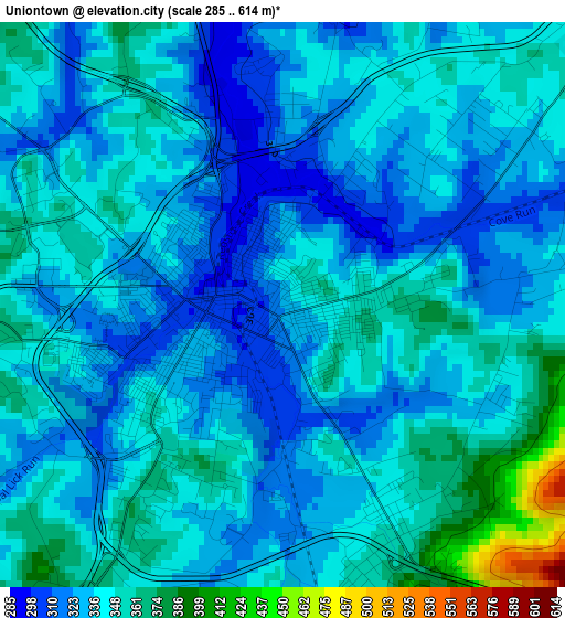
Below is the Elevation map of Uniontown, which displays elevation range with different colors. Scale of the first map is from 285 to 614 m (935 to 2014 ft) with average elevation of 339.7 meters (=1115 ft) [note 1]
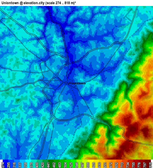
These maps also provides idea of topography and contour of this city, they are displayed at different zoom levels. More info about maps, scale and edge coordinates you can find below images.
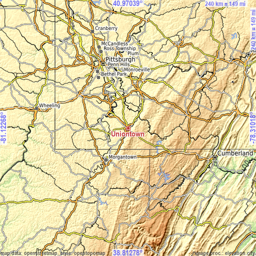
| \ | Map #1 | Map #2 | Topo.Map |
| Scale [m] | 285..614 m | 274..818 m | × |
| Scale [ft] | 935..2014 ft | 899..2684 ft | × |
| Average | 339.7 m = 1115 ft | 403.8 m = 1325 ft | × |
| Width | 7.5 km = 4.7 mi | 14.99 km = 9.3 mi | 239.9 km = 149.1 mi |
| Height | 7.5 km = 4.7 mi | 14.99 km = 9.3 mi | 239.9 km = 149.1 mi |
| ↑Max Latitude | 39.933785° | 39.967473° | 40.97039° |
| Latitude at center | 39.90008° | 39.90008° | 39.90008° |
| ↓Min Latitude | 39.866358° | 39.83262° | 38.81278° |
| ← Min Longitude | -79.760375° | -79.804321° | -81.12268° |
| Longitude center | -79.71643° | -79.71643° | -79.71643° |
| →Max Longitude | -79.672485° | -79.628539° | -78.31018° |
Nearby cities:
Cities around Uniontown sort by population:
• Connellsville elevation 283 m
17 km,  39°
39°
• Masontown 315 m
16.7 km,  249°
249°
• Leith-Hatfield 343 m
2.8 km,  206°
206°
• Oliver 308 m
2.1 km,  356°
356°
• East Uniontown 369 m
1.6 km,  91°
91°
• Brownsville 247 m
19.8 km,  313°
313°
• Hopwood 338 m
2.8 km,  154°
154°
• South Connellsville 320 m
15.5 km,  45°
45°
• Fairchance 334 m
9 km,  201°
201°
• South Uniontown 328 m
2.7 km, 252°
• Republic 297 m
15.3 km,  296°
296°
• Dunbar 321 m
12.3 km, 45°
Multilingual:
 En español:
Uniontown elevación 326 m.
 En France:
Uniontown élévation 326 m.
 Auf Deutsch:
Uniontown höhe über dem Meeresspiegel ist 326 m.

Sources and notes:
- [note 1] Map square and city borders are not equal. Map elevation data is calculated only from area inside that square.
- [src 1] Elevation data from geonames database provided with same terms of usage.
- [src 2] The elevation map of Uniontown is generated using elevation data from NASA's 3 arcsec (90m) resolution SRTM data.
- [src 3] Base (background) map © OpenStreetMap contributors tiles are generated by Geofabrik and OpenTopoMap.
Copyright & License:
This Uniontown Elevation Map is licensed under CC BY-SA. You may reuse any part from this page, if you give a proper credit by linking to this URL:
 More info on terms of use page.