Stewartstown elevation
Stewartstown (Pennsylvania, York County), United States elevation is 268 meters and Stewartstown elevation in feet is 879 ft above sea level [src 1]. Stewartstown is a populated place (feature code) with elevation that is 11 meters (36 ft) smaller than average city elevation in United States.
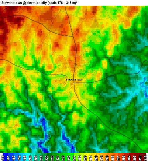
Below is the Elevation map of Stewartstown, which displays elevation range with different colors. Scale of the first map is from 176 to 318 m (577 to 1043 ft) with average elevation of 244.9 meters (=803 ft) [note 1]
These maps also provides idea of topography and contour of this city, they are displayed at different zoom levels. More info about maps, scale and edge coordinates you can find below images.
| \ | Map #1 | Topo.Map |
| Scale [m] | 176..318 m | × |
| Scale [ft] | 577..1043 ft | × |
| Average | 244.9 m = 803 ft | × |
| Width | 7.51 km = 4.7 mi | 240.4 km = 149.4 mi |
| Height | 7.51 km = 4.7 mi | 240.4 km = 149.4 mi |
| ↑Max Latitude | 39.787487° | 40.82633° |
| Latitude at center | 39.75371° | 39.75371° |
| ↓Min Latitude | 39.719917° | 38.66412° |
| ← Min Longitude | -76.635305° | -77.99761° |
| Longitude center | -76.59136° | -76.59136° |
| →Max Longitude | -76.547415° | -75.18511° |
Nearby cities:
Cities around Stewartstown sort by population:
• Red Lion elevation 281 m
16.4 km,  355°
355°
• Spry 218 m
20 km,  336°
336°
• New Freedom 252 m
9.6 km,  259°
259°
• Dallastown 273 m
16.7 km,  345°
345°
• Shrewsbury 299 m
7.7 km,  282°
282°
• Jarrettsville 195 m
19.2 km,  149°
149°
• Susquehanna Trails 141 m
19.1 km,  88°
88°
• Glen Rock 170 m
12.7 km,  290°
290°
• Jacobus 205 m
17.6 km,  324°
324°
• Windsor 210 m
18.1 km,  1°
1°
• Loganville 238 m
15.1 km, 318°
• Yoe 219 m
17.7 km, 347°
Multilingual:
 En español:
Stewartstown elevación 268 m.
 En France:
Stewartstown élévation 268 m.
 Auf Deutsch:
Stewartstown höhe über dem Meeresspiegel ist 268 m.

Sources and notes:
- [note 1] Map square and city borders are not equal. Map elevation data is calculated only from area inside that square.
- [src 1] Elevation data from geonames database provided with same terms of usage.
- [src 2] The elevation map of Stewartstown is generated using elevation data from NASA's 3 arcsec (90m) resolution SRTM data.
- [src 3] Base (background) map © OpenStreetMap contributors tiles are generated by Geofabrik and OpenTopoMap.
Copyright & License:
This Stewartstown Elevation Map is licensed under CC BY-SA. You may reuse any part from this page, if you give a proper credit by linking to this URL:
 More info on terms of use page.