Milford elevation
Milford (Pennsylvania, Somerset County), United States elevation is 594 meters and Milford elevation in feet is 1949 ft above sea level [src 1]. Milford is a populated place (feature code) with elevation that is 315 meters (1033 ft) bigger than average city elevation in United States.
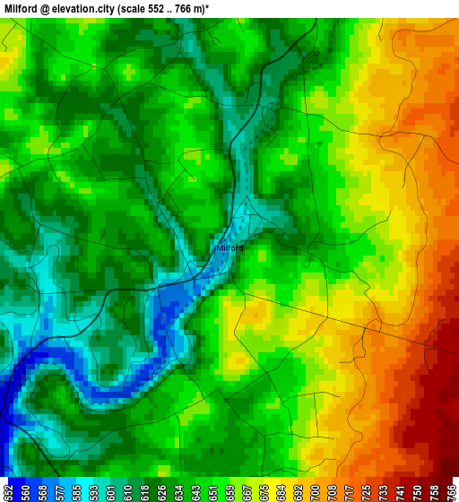
Below is the Elevation map of Milford, which displays elevation range with different colors. Scale of the first map is from 552 to 766 m (1811 to 2513 ft) with average elevation of 649.7 meters (=2132 ft) [note 1]
These maps also provides idea of topography and contour of this city, they are displayed at different zoom levels. More info about maps, scale and edge coordinates you can find below images.
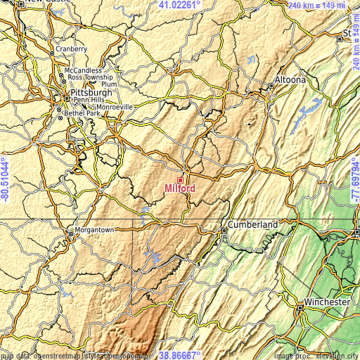
| \ | Map #1 | Topo.Map |
| Scale [m] | 552..766 m | × |
| Scale [ft] | 1811..2513 ft | × |
| Average | 649.7 m = 2132 ft | × |
| Width | 7.49 km = 4.7 mi | 239.7 km = 148.9 mi |
| Height | 7.49 km = 4.7 mi | 239.7 km = 148.9 mi |
| ↑Max Latitude | 39.986809° | 41.02261° |
| Latitude at center | 39.95313° | 39.95313° |
| ↓Min Latitude | 39.919435° | 38.86667° |
| ← Min Longitude | -79.148135° | -80.51044° |
| Longitude center | -79.10419° | -79.10419° |
| →Max Longitude | -79.060245° | -77.69794° |
Nearby cities:
Cities around Milford sort by population:
• Frostburg elevation 629 m
36.1 km,  155°
155°
• Somerset 661 m
6.5 km,  19°
19°
• Meyersdale 604 m
16.9 km, 156°
• Berlin 704 m
13 km,  106°
106°
• Ligonier 368 m
34.2 km,  340°
340°
• Friedens 642 m
14.1 km,  39°
39°
• Waterford 405 m
33.9 km,  350°
350°
• Boswell 567 m
24 km, 15°
• Davidsville 529 m
33.6 km,  25°
25°
• Central City 671 m
31.1 km,  55°
55°
• Bear Rocks 610 m
35.8 km,  301°
301°
• Jerome 548 m
30.2 km, 19°
Multilingual:
 En español:
Milford elevación 594 m.
 En France:
Milford élévation 594 m.


Sources and notes:
- [note 1] Map square and city borders are not equal. Map elevation data is calculated only from area inside that square.
- [src 1] Elevation data from geonames database provided with same terms of usage.
- [src 2] The elevation map of Milford is generated using elevation data from NASA's 3 arcsec (90m) resolution SRTM data.
- [src 3] Base (background) map © OpenStreetMap contributors tiles are generated by Geofabrik and OpenTopoMap.
Copyright & License:
This Milford Elevation Map is licensed under CC BY-SA. You may reuse any part from this page, if you give a proper credit by linking to this URL:
 More info on terms of use page.