Luzerne elevation
Luzerne (Pennsylvania, Fayette County), United States elevation is 237 meters and Luzerne elevation in feet is 778 ft above sea level [src 1]. Luzerne is a populated place (feature code) with elevation that is 42 meters (138 ft) smaller than average city elevation in United States.
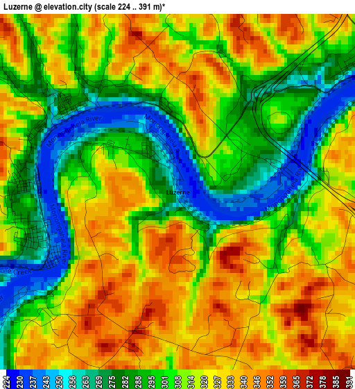
Below is the Elevation map of Luzerne, which displays elevation range with different colors. Scale of the first map is from 224 to 391 m (735 to 1283 ft) with average elevation of 309.8 meters (=1016 ft) [note 1]
These maps also provides idea of topography and contour of this city, they are displayed at different zoom levels. More info about maps, scale and edge coordinates you can find below images.
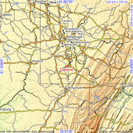
| \ | Map #1 | Topo.Map |
| Scale [m] | 224..391 m | × |
| Scale [ft] | 735..1283 ft | × |
| Average | 309.8 m = 1016 ft | × |
| Width | 7.49 km = 4.7 mi | 239.6 km = 148.9 mi |
| Height | 7.49 km = 4.7 mi | 239.6 km = 148.9 mi |
| ↑Max Latitude | 40.032896° | 41.06799° |
| Latitude at center | 39.99924° | 39.99924° |
| ↓Min Latitude | 39.965567° | 38.9135° |
| ← Min Longitude | -80.006775° | -81.36908° |
| Longitude center | -79.96283° | -79.96283° |
| →Max Longitude | -79.918885° | -78.55658° |
Nearby cities:
Cities around Luzerne sort by population:
• Maple Glen elevation 247 m
2.2 km,  327°
327°
• California 241 m
9.5 km,  39°
39°
• Charleroi 241 m
16.4 km,  19°
19°
• Centerville 354 m
5.2 km,  348°
348°
• Bentleyville 289 m
13.6 km,  343°
343°
• Brownsville 247 m
7.2 km,  67°
67°
• Fairdale 304 m
12.5 km,  182°
182°
• Hiller 311 m
5.4 km,  76°
76°
• Fairhope 287 m
16.5 km, 39°
• Speers 252 m
15.6 km,  26°
26°
• Republic 297 m
8.4 km,  119°
119°
• Belle Vernon 238 m
16.2 km, 30°
Multilingual:
 En español:
Luzerne elevación 237 m.
 En France:
Luzerne élévation 237 m.


Sources and notes:
- [note 1] Map square and city borders are not equal. Map elevation data is calculated only from area inside that square.
- [src 1] Elevation data from geonames database provided with same terms of usage.
- [src 2] The elevation map of Luzerne is generated using elevation data from NASA's 3 arcsec (90m) resolution SRTM data.
- [src 3] Base (background) map © OpenStreetMap contributors tiles are generated by Geofabrik and OpenTopoMap.
Copyright & License:
This Luzerne Elevation Map is licensed under CC BY-SA. You may reuse any part from this page, if you give a proper credit by linking to this URL:
 More info on terms of use page.