East Berlin elevation
East Berlin (Pennsylvania, Adams County), United States elevation is 129 meters and East Berlin elevation in feet is 423 ft above sea level [src 1]. East Berlin is a populated place (feature code) with elevation that is 150 meters (492 ft) smaller than average city elevation in United States.
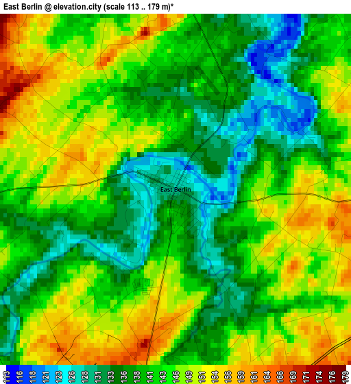
Below is the Elevation map of East Berlin, which displays elevation range with different colors. Scale of the first map is from 113 to 179 m (371 to 587 ft) with average elevation of 142.8 meters (=469 ft) [note 1]
These maps also provides idea of topography and contour of this city, they are displayed at different zoom levels. More info about maps, scale and edge coordinates you can find below images.
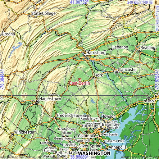
| \ | Map #1 | Topo.Map |
| Scale [m] | 113..179 m | × |
| Scale [ft] | 371..587 ft | × |
| Average | 142.8 m = 469 ft | × |
| Width | 7.49 km = 4.7 mi | 239.8 km = 149 mi |
| Height | 7.49 km = 4.7 mi | 239.8 km = 149 mi |
| ↑Max Latitude | 39.971287° | 41.00732° |
| Latitude at center | 39.9376° | 39.9376° |
| ↓Min Latitude | 39.903897° | 38.85089° |
| ← Min Longitude | -77.022535° | -78.38484° |
| Longitude center | -76.97859° | -76.97859° |
| →Max Longitude | -76.934645° | -75.57234° |
Nearby cities:
Cities around East Berlin sort by population:
• Hanover elevation 188 m
15.2 km,  181°
181°
• Weigelstown 155 m
14.3 km,  68°
68°
• Shiloh 140 m
16.1 km, 73°
• Parkville 235 m
17.4 km, 175°
• McSherrystown 181 m
14.8 km,  190°
190°
• Lake Meade 158 m
7.3 km,  316°
316°
• Spring Grove 144 m
11.9 km,  126°
126°
• Midway 172 m
14.5 km, 188°
• Dover 136 m
13.1 km,  56°
56°
• Pennville 171 m
16.5 km, 185°
• New Oxford 172 m
10.5 km,  218°
218°
• Abbottstown 168 m
5.7 km, 185°
Multilingual:
 En español:
East Berlin elevación 129 m.
 En France:
East Berlin élévation 129 m.
 Auf Deutsch:
East Berlin höhe über dem Meeresspiegel ist 129 m.

Sources and notes:
- [note 1] Map square and city borders are not equal. Map elevation data is calculated only from area inside that square.
- [src 1] Elevation data from geonames database provided with same terms of usage.
- [src 2] The elevation map of East Berlin is generated using elevation data from NASA's 3 arcsec (90m) resolution SRTM data.
- [src 3] Base (background) map © OpenStreetMap contributors tiles are generated by Geofabrik and OpenTopoMap.
Copyright & License:
This East Berlin Elevation Map is licensed under CC BY-SA. You may reuse any part from this page, if you give a proper credit by linking to this URL:
 More info on terms of use page.