McLoud elevation
McLoud (Oklahoma, Pottawatomie County), United States elevation is 337 meters and McLoud elevation in feet is 1106 ft above sea level [src 1]. McLoud is a populated place (feature code) with elevation that is 58 meters (190 ft) bigger than average city elevation in United States.
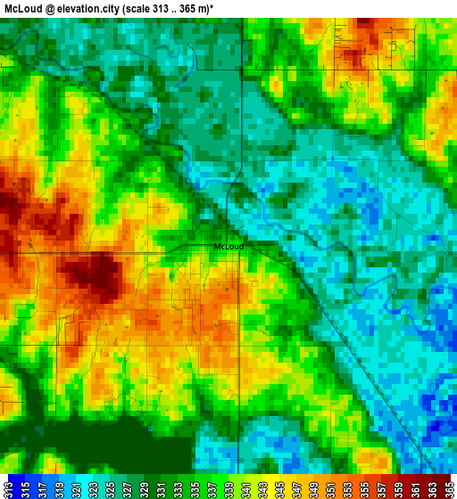
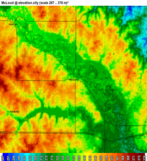
Below is the Elevation map of McLoud, which displays elevation range with different colors. Scale of the first map is from 313 to 365 m (1027 to 1198 ft) with average elevation of 334.2 meters (=1096 ft) [note 1]
These maps also provides idea of topography and contour of this city, they are displayed at different zoom levels. More info about maps, scale and edge coordinates you can find below images.
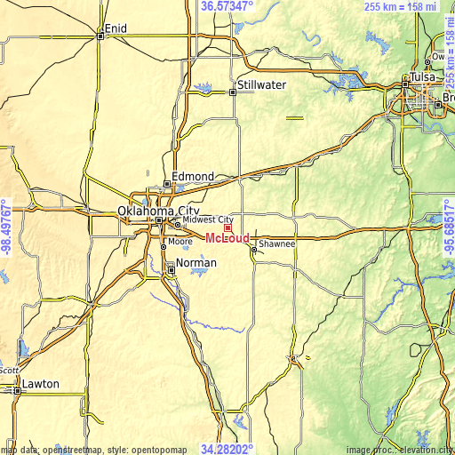
| \ | Map #1 | Map #2 | Topo.Map |
| Scale [m] | 313..365 m | 287..378 m | × |
| Scale [ft] | 1027..1198 ft | 942..1240 ft | × |
| Average | 334.2 m = 1096 ft | 336.6 m = 1104 ft | × |
| Width | 7.96 km = 4.9 mi | 15.92 km = 9.9 mi | 254.8 km = 158.3 mi |
| Height | 7.96 km = 4.9 mi | 15.92 km = 9.9 mi | 254.8 km = 158.3 mi |
| ↑Max Latitude | 35.471697° | 35.507478° | 36.57347° |
| Latitude at center | 35.4359° | 35.4359° | 35.4359° |
| ↓Min Latitude | 35.400087° | 35.364258° | 34.28202° |
| ← Min Longitude | -97.135365° | -97.179311° | -98.49767° |
| Longitude center | -97.09142° | -97.09142° | -97.09142° |
| →Max Longitude | -97.047475° | -97.003529° | -95.68517° |
Nearby cities:
Cities around McLoud sort by population:
• Midwest City elevation 386 m
27.7 km,  273°
273°
• Shawnee 326 m
19.3 km,  128°
128°
• Choctaw 353 m
17.5 km,  293°
293°
• Tecumseh 336 m
24.3 km,  144°
144°
• Harrah 340 m
8.8 km,  312°
312°
• Spencer 367 m
27.6 km, 290°
• Bethel Acres 348 m
15.4 km,  157°
157°
• Jones 344 m
22.9 km, 309°
• Nicoma Park 373 m
21.9 km, 286°
• Pink 343 m
19.7 km,  187°
187°
• Luther 286 m
26.8 km,  339°
339°
• Meeker 278 m
18.7 km,  66°
66°
Multilingual:
 En español:
McLoud elevación 337 m.
 En France:
McLoud élévation 337 m.


Sources and notes:
- [note 1] Map square and city borders are not equal. Map elevation data is calculated only from area inside that square.
- [src 1] Elevation data from geonames database provided with same terms of usage.
- [src 2] The elevation map of McLoud is generated using elevation data from NASA's 3 arcsec (90m) resolution SRTM data.
- [src 3] Base (background) map © OpenStreetMap contributors tiles are generated by Geofabrik and OpenTopoMap.
Copyright & License:
This McLoud Elevation Map is licensed under CC BY-SA. You may reuse any part from this page, if you give a proper credit by linking to this URL:
 More info on terms of use page.