Lawton elevation
Lawton (Oklahoma, Comanche County), United States elevation is 342 meters and Lawton elevation in feet is 1122 ft above sea level [src 1]. Lawton is a seat of a second-order administrative division (feature code) with elevation that is 63 meters (207 ft) bigger than average city elevation in United States.
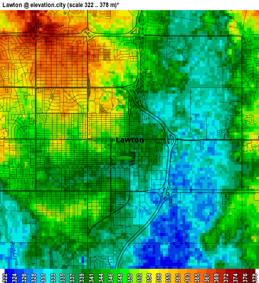
Below is the Elevation map of Lawton, which displays elevation range with different colors. Scale of the first map is from 322 to 378 m (1056 to 1240 ft) with average elevation of 343.7 meters (=1128 ft) [note 1]
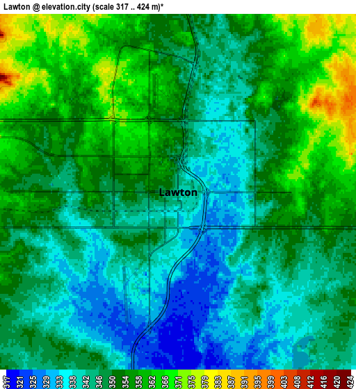
These maps also provides idea of topography and contour of this city, they are displayed at different zoom levels. More info about maps, scale and edge coordinates you can find below images.
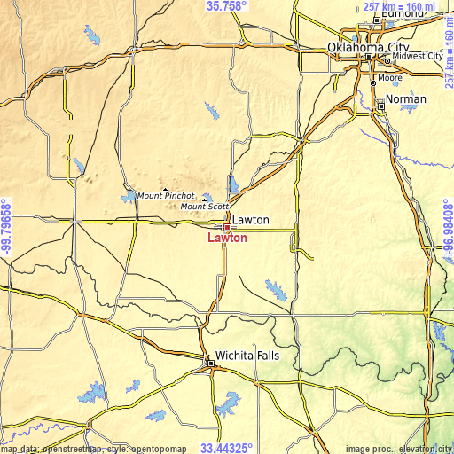
| \ | Map #1 | Map #2 | Topo.Map |
| Scale [m] | 322..378 m | 317..424 m | × |
| Scale [ft] | 1056..1240 ft | 1040..1391 ft | × |
| Average | 343.7 m = 1128 ft | 349.2 m = 1146 ft | × |
| Width | 8.04 km = 5 mi | 16.09 km = 10 mi | 257.4 km = 159.9 mi |
| Height | 8.04 km = 5 mi | 16.09 km = 10 mi | 257.4 km = 159.9 mi |
| ↑Max Latitude | 34.644851° | 34.680997° | 35.758° |
| Latitude at center | 34.60869° | 34.60869° | 34.60869° |
| ↓Min Latitude | 34.572513° | 34.53632° | 33.44325° |
| ← Min Longitude | -98.434275° | -98.478221° | -99.79658° |
| Longitude center | -98.39033° | -98.39033° | -98.39033° |
| →Max Longitude | -98.346385° | -98.302439° | -96.98408° |
Nearby cities:
Cities around Lawton sort by population:
• Duncan elevation 348 m
41.3 km,  106°
106°
• Marlow 403 m
39.8 km,  83°
83°
• Marlow 393 m
39.8 km,  92°
92°
• Elgin 398 m
21.1 km,  25°
25°
• Cache 392 m
21.9 km,  276°
276°
• Walters 309 m
28.7 km,  164°
164°
• Meridian 339 m
42.8 km,  118°
118°
• Apache 396 m
31.8 km,  4°
4°
• Geronimo 339 m
14.2 km,  177°
177°
• Central High 362 m
27.6 km, 86°
• Fletcher 422 m
27.3 km, 29°
• Cyril 418 m
36.4 km, 28°
Multilingual:
 En español:
Lawton elevación 342 m.
 En France:
Lawton élévation 342 m.


Sources and notes:
- [note 1] Map square and city borders are not equal. Map elevation data is calculated only from area inside that square.
- [src 1] Elevation data from geonames database provided with same terms of usage.
- [src 2] The elevation map of Lawton is generated using elevation data from NASA's 3 arcsec (90m) resolution SRTM data.
- [src 3] Base (background) map © OpenStreetMap contributors tiles are generated by Geofabrik and OpenTopoMap.
Copyright & License:
This Lawton Elevation Map is licensed under CC BY-SA. You may reuse any part from this page, if you give a proper credit by linking to this URL:
 More info on terms of use page.