Cheyenne elevation
Cheyenne (Oklahoma, Roger Mills County), United States elevation is 603 meters and Cheyenne elevation in feet is 1978 ft above sea level [src 1]. Cheyenne is a seat of a second-order administrative division (feature code) with elevation that is 324 meters (1063 ft) bigger than average city elevation in United States.
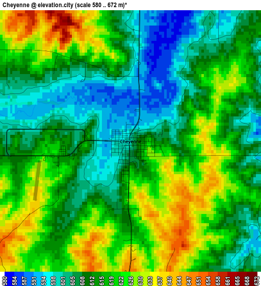
Below is the Elevation map of Cheyenne, which displays elevation range with different colors. Scale of the first map is from 580 to 672 m (1903 to 2205 ft) with average elevation of 615 meters (=2018 ft) [note 1]
These maps also provides idea of topography and contour of this city, they are displayed at different zoom levels. More info about maps, scale and edge coordinates you can find below images.
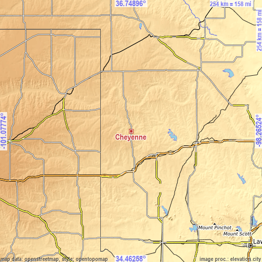
| \ | Map #1 | Topo.Map |
| Scale [m] | 580..672 m | × |
| Scale [ft] | 1903..2205 ft | × |
| Average | 615 m = 2018 ft | × |
| Width | 7.94 km = 4.9 mi | 254.2 km = 158 mi |
| Height | 7.94 km = 4.9 mi | 254.2 km = 158 mi |
| ↑Max Latitude | 35.649658° | 36.74896° |
| Latitude at center | 35.61394° | 35.61394° |
| ↓Min Latitude | 35.578206° | 34.46258° |
| ← Min Longitude | -99.715435° | -101.07774° |
| Longitude center | -99.67149° | -99.67149° |
| →Max Longitude | -99.627545° | -98.26524° |
Nearby cities:
Cities around Cheyenne sort by population:
• Elk City elevation 590 m
33 km,  132°
132°
• Clinton 482 m
64.6 km,  99°
99°
• Sayre 554 m
36 km,  175°
175°
• Canadian 746 m
72.2 km,  297°
297°
• Cordell 481 m
71.6 km,  120°
120°
• Burns Flat 582 m
54.1 km, 122°
• Shamrock 718 m
68.7 km,  229°
229°
• Wheeler 768 m
57.4 km,  250°
250°
• Shattuck 691 m
76 km,  345°
345°
• Erick 633 m
47.7 km,  201°
201°
• Arapaho 509 m
64 km,  93°
93°
• Arnett 755 m
58.7 km, 350°
Multilingual:
 En español:
Cheyenne elevación 603 m.
 En France:
Cheyenne élévation 603 m.
 Auf Deutsch:
Cheyenne höhe über dem Meeresspiegel ist 603 m.

Sources and notes:
- [note 1] Map square and city borders are not equal. Map elevation data is calculated only from area inside that square.
- [src 1] Elevation data from geonames database provided with same terms of usage.
- [src 2] The elevation map of Cheyenne is generated using elevation data from NASA's 3 arcsec (90m) resolution SRTM data.
- [src 3] Base (background) map © OpenStreetMap contributors tiles are generated by Geofabrik and OpenTopoMap.
Copyright & License:
This Cheyenne Elevation Map is licensed under CC BY-SA. You may reuse any part from this page, if you give a proper credit by linking to this URL:
 More info on terms of use page.