Sherwood elevation
Sherwood (Ohio, Hamilton County), United States elevation is 223 meters and Sherwood elevation in feet is 732 ft above sea level [src 1]. Sherwood is a populated place (feature code) with elevation that is 56 meters (184 ft) smaller than average city elevation in United States.
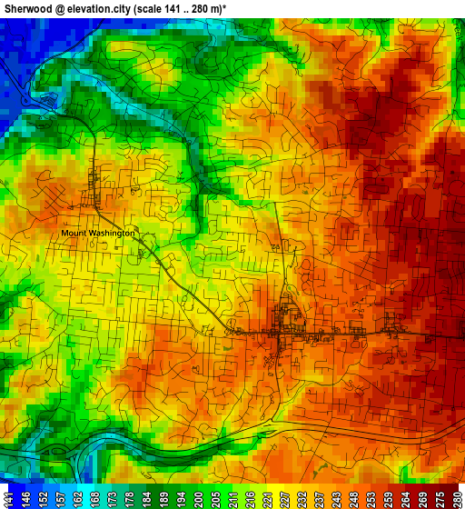
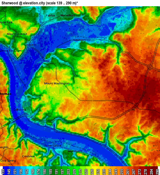
Below is the Elevation map of Sherwood, which displays elevation range with different colors. Scale of the first map is from 141 to 280 m (463 to 919 ft) with average elevation of 228.3 meters (=749 ft) [note 1]
These maps also provides idea of topography and contour of this city, they are displayed at different zoom levels. More info about maps, scale and edge coordinates you can find below images.
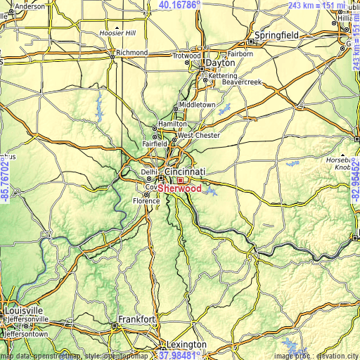
| \ | Map #1 | Map #2 | Topo.Map |
| Scale [m] | 141..280 m | 139..290 m | × |
| Scale [ft] | 463..919 ft | 456..951 ft | × |
| Average | 228.3 m = 749 ft | 211.3 m = 693 ft | × |
| Width | 7.59 km = 4.7 mi | 15.17 km = 9.4 mi | 242.7 km = 150.8 mi |
| Height | 7.59 km = 4.7 mi | 15.17 km = 9.4 mi | 242.7 km = 150.8 mi |
| ↑Max Latitude | 39.118883° | 39.152969° | 40.16786° |
| Latitude at center | 39.08478° | 39.08478° | 39.08478° |
| ↓Min Latitude | 39.050661° | 39.016525° | 37.98481° |
| ← Min Longitude | -84.404715° | -84.448661° | -85.76702° |
| Longitude center | -84.36077° | -84.36077° | -84.36077° |
| →Max Longitude | -84.316825° | -84.272879° | -82.95452° |
Nearby cities:
Cities around Sherwood sort by population:
• Forestville elevation 253 m
1.7 km,  128°
128°
• Dry Run 266 m
3.4 km,  50°
50°
• Withamsville 266 m
6.7 km,  111°
111°
• Turpin Hills 202 m
3.3 km,  329°
329°
• Summerside 268 m
6.6 km,  70°
70°
• Mount Carmel 269 m
5.4 km,  64°
64°
• Cherry Grove 267 m
3.6 km, 112°
• Salem Heights 229 m
2.1 km,  226°
226°
• Fruit Hill 225 m
1.1 km,  197°
197°
• Mariemont 181 m
6.8 km,  350°
350°
• Newtown 154 m
4.4 km,  359°
359°
• Silver Grove 154 m
6.1 km, 204°
Multilingual:
 En español:
Sherwood elevación 223 m.
 En France:
Sherwood élévation 223 m.
 Auf Deutsch:
Sherwood höhe über dem Meeresspiegel ist 223 m.

Sources and notes:
- [note 1] Map square and city borders are not equal. Map elevation data is calculated only from area inside that square.
- [src 1] Elevation data from geonames database provided with same terms of usage.
- [src 2] The elevation map of Sherwood is generated using elevation data from NASA's 3 arcsec (90m) resolution SRTM data.
- [src 3] Base (background) map © OpenStreetMap contributors tiles are generated by Geofabrik and OpenTopoMap.
Copyright & License:
This Sherwood Elevation Map is licensed under CC BY-SA. You may reuse any part from this page, if you give a proper credit by linking to this URL:
 More info on terms of use page.