Sciotodale elevation
Sciotodale (Ohio, Scioto County), United States elevation is 192 meters and Sciotodale elevation in feet is 630 ft above sea level [src 1]. Sciotodale is a populated place (feature code) with elevation that is 87 meters (285 ft) smaller than average city elevation in United States.
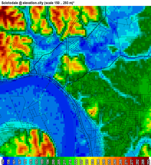
Below is the Elevation map of Sciotodale, which displays elevation range with different colors. Scale of the first map is from 150 to 293 m (492 to 961 ft) with average elevation of 192 meters (=630 ft) [note 1]
These maps also provides idea of topography and contour of this city, they are displayed at different zoom levels. More info about maps, scale and edge coordinates you can find below images.
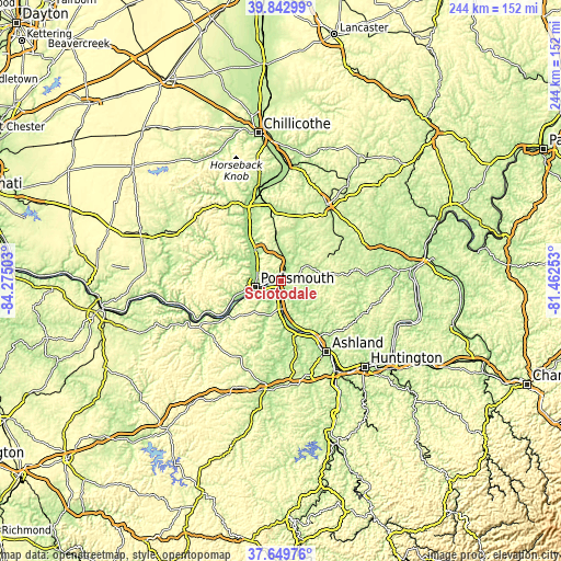
| \ | Map #1 | Topo.Map |
| Scale [m] | 150..293 m | × |
| Scale [ft] | 492..961 ft | × |
| Average | 192 m = 630 ft | × |
| Width | 7.62 km = 4.7 mi | 243.9 km = 151.6 mi |
| Height | 7.62 km = 4.7 mi | 243.9 km = 151.6 mi |
| ↑Max Latitude | 38.789062° | 39.84299° |
| Latitude at center | 38.7548° | 38.7548° |
| ↓Min Latitude | 38.720522° | 37.64976° |
| ← Min Longitude | -82.912725° | -84.27503° |
| Longitude center | -82.86878° | -82.86878° |
| →Max Longitude | -82.824835° | -81.46253° |
Nearby cities:
Cities around Sciotodale sort by population:
• Portsmouth elevation 164 m
11.5 km,  257°
257°
• Wheelersburg 168 m
3 km,  156°
156°
• West Portsmouth 189 m
13.9 km,  271°
271°
• Lucasville 169 m
17.8 km,  321°
321°
• Raceland 169 m
26.8 km,  152°
152°
• New Boston 166 m
5.9 km, 267°
• Rosemount 187 m
10.2 km,  290°
290°
• Franklin Furnace 171 m
12.3 km,  171°
171°
• Worthington 170 m
26.2 km, 151°
• Greenup 163 m
20.5 km, 170°
• South Shore 166 m
8.6 km,  244°
244°
• Wurtland 167 m
24.1 km, 160°
Multilingual:
 En español:
Sciotodale elevación 192 m.
 En France:
Sciotodale élévation 192 m.
 Auf Deutsch:
Sciotodale höhe über dem Meeresspiegel ist 192 m.

Sources and notes:
- [note 1] Map square and city borders are not equal. Map elevation data is calculated only from area inside that square.
- [src 1] Elevation data from geonames database provided with same terms of usage.
- [src 2] The elevation map of Sciotodale is generated using elevation data from NASA's 3 arcsec (90m) resolution SRTM data.
- [src 3] Base (background) map © OpenStreetMap contributors tiles are generated by Geofabrik and OpenTopoMap.
Copyright & License:
This Sciotodale Elevation Map is licensed under CC BY-SA. You may reuse any part from this page, if you give a proper credit by linking to this URL:
 More info on terms of use page.