Glendale elevation
Glendale (Ohio, Hamilton County), United States elevation is 194 meters and Glendale elevation in feet is 636 ft above sea level [src 1]. Glendale is a populated place (feature code) with elevation that is 85 meters (279 ft) smaller than average city elevation in United States.
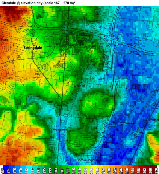
Below is the Elevation map of Glendale, which displays elevation range with different colors. Scale of the first map is from 167 to 270 m (548 to 886 ft) with average elevation of 202.3 meters (=664 ft) [note 1]
These maps also provides idea of topography and contour of this city, they are displayed at different zoom levels. More info about maps, scale and edge coordinates you can find below images.
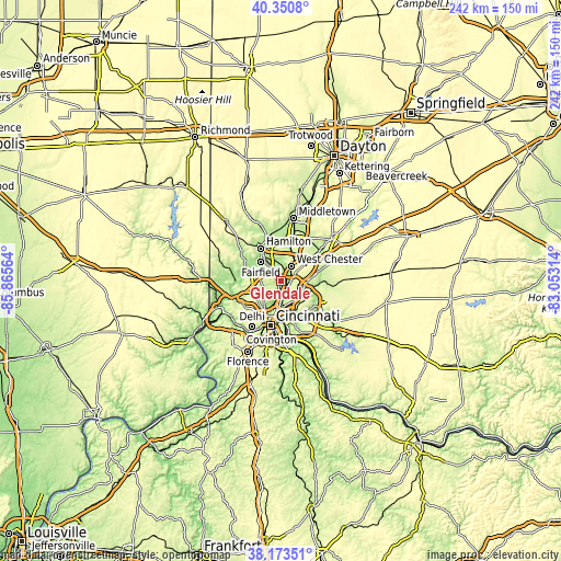
| \ | Map #1 | Topo.Map |
| Scale [m] | 167..270 m | × |
| Scale [ft] | 548..886 ft | × |
| Average | 202.3 m = 664 ft | × |
| Width | 7.57 km = 4.7 mi | 242.1 km = 150.4 mi |
| Height | 7.57 km = 4.7 mi | 242.1 km = 150.4 mi |
| ↑Max Latitude | 39.304623° | 40.3508° |
| Latitude at center | 39.27061° | 39.27061° |
| ↓Min Latitude | 39.236581° | 38.17351° |
| ← Min Longitude | -84.503335° | -85.86564° |
| Longitude center | -84.45939° | -84.45939° |
| →Max Longitude | -84.415445° | -83.05314° |
Nearby cities:
Cities around Glendale sort by population:
• Forest Park elevation 258 m
4.4 km,  299°
299°
• Sharonville 178 m
4 km,  94°
94°
• Springdale 226 m
2.9 km,  309°
309°
• Reading 173 m
5.4 km,  164°
164°
• Wyoming 179 m
4.4 km,  187°
187°
• Greenhills 249 m
5.5 km,  267°
267°
• Amberley 249 m
7.8 km, 159°
• Dillonvale 245 m
7.6 km,  139°
139°
• Lockland 176 m
4.6 km,  178°
178°
• Lincoln Heights 183 m
3.5 km,  174°
174°
• Woodlawn 180 m
2.3 km,  204°
204°
• Evendale 179 m
3.9 km,  114°
114°
Multilingual:
 En español:
Glendale elevación 194 m.
 En France:
Glendale élévation 194 m.
 Auf Deutsch:
Glendale höhe über dem Meeresspiegel ist 194 m.

Sources and notes:
- [note 1] Map square and city borders are not equal. Map elevation data is calculated only from area inside that square.
- [src 1] Elevation data from geonames database provided with same terms of usage.
- [src 2] The elevation map of Glendale is generated using elevation data from NASA's 3 arcsec (90m) resolution SRTM data.
- [src 3] Base (background) map © OpenStreetMap contributors tiles are generated by Geofabrik and OpenTopoMap.
Copyright & License:
This Glendale Elevation Map is licensed under CC BY-SA. You may reuse any part from this page, if you give a proper credit by linking to this URL:
 More info on terms of use page.