Dent elevation
Dent (Ohio, Hamilton County), United States elevation is 255 meters and Dent elevation in feet is 837 ft above sea level [src 1]. Dent is a populated place (feature code) with elevation that is 24 meters (79 ft) smaller than average city elevation in United States.
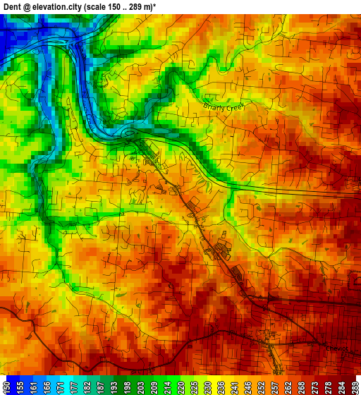
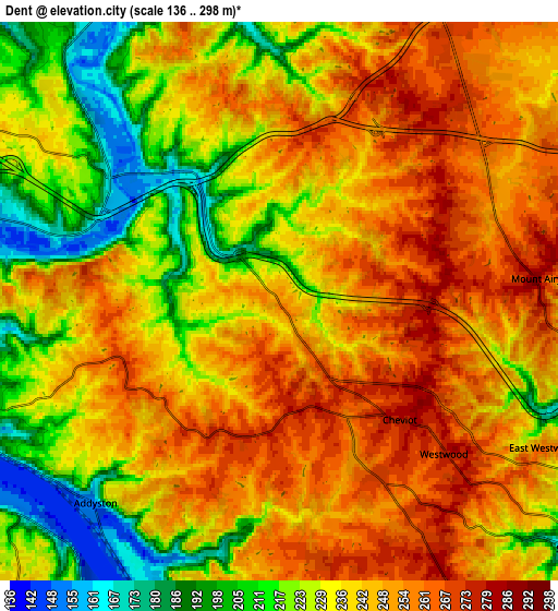
Below is the Elevation map of Dent, which displays elevation range with different colors. Scale of the first map is from 150 to 289 m (492 to 948 ft) with average elevation of 242.8 meters (=797 ft) [note 1]
These maps also provides idea of topography and contour of this city, they are displayed at different zoom levels. More info about maps, scale and edge coordinates you can find below images.
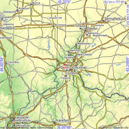
| \ | Map #1 | Map #2 | Topo.Map |
| Scale [m] | 150..289 m | 136..298 m | × |
| Scale [ft] | 492..948 ft | 446..978 ft | × |
| Average | 242.8 m = 797 ft | 238.6 m = 783 ft | × |
| Width | 7.57 km = 4.7 mi | 15.15 km = 9.4 mi | 242.4 km = 150.6 mi |
| Height | 7.57 km = 4.7 mi | 15.15 km = 9.4 mi | 242.4 km = 150.6 mi |
| ↑Max Latitude | 39.219944° | 39.253981° | 40.2674° |
| Latitude at center | 39.18589° | 39.18589° | 39.18589° |
| ↓Min Latitude | 39.15182° | 39.117733° | 38.08748° |
| ← Min Longitude | -84.695285° | -84.739231° | -86.05759° |
| Longitude center | -84.65134° | -84.65134° | -84.65134° |
| →Max Longitude | -84.607395° | -84.563449° | -83.24509° |
Nearby cities:
Cities around Dent sort by population:
• White Oak elevation 280 m
5.4 km,  55°
55°
• Bridgetown 274 m
3.8 km,  161°
161°
• Monfort Heights 272 m
4.8 km,  86°
86°
• Mack 276 m
3.1 km,  177°
177°
• Cheviot 278 m
4.6 km,  134°
134°
• Groesbeck 262 m
6.9 km,  53°
53°
• Covedale 271 m
8.2 km,  151°
151°
• Miami Heights 251 m
6.4 km,  248°
248°
• Dry Ridge 279 m
8.6 km,  18°
18°
• Skyline Acres 256 m
8.7 km, 56°
• Grandview 221 m
6.4 km,  278°
278°
• Miamitown 159 m
5.6 km,  306°
306°
Multilingual:
 En español:
Dent elevación 255 m.
 En France:
Dent élévation 255 m.


Sources and notes:
- [note 1] Map square and city borders are not equal. Map elevation data is calculated only from area inside that square.
- [src 1] Elevation data from geonames database provided with same terms of usage.
- [src 2] The elevation map of Dent is generated using elevation data from NASA's 3 arcsec (90m) resolution SRTM data.
- [src 3] Base (background) map © OpenStreetMap contributors tiles are generated by Geofabrik and OpenTopoMap.
Copyright & License:
This Dent Elevation Map is licensed under CC BY-SA. You may reuse any part from this page, if you give a proper credit by linking to this URL:
 More info on terms of use page.