Dayton elevation
Dayton (Ohio, Montgomery County), United States elevation is 237 meters and Dayton elevation in feet is 778 ft above sea level [src 1]. Dayton is a seat of a second-order administrative division (feature code) with elevation that is 42 meters (138 ft) smaller than average city elevation in United States.
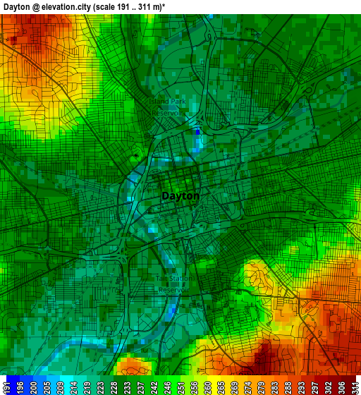
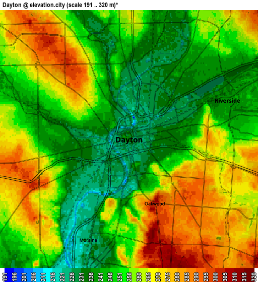
Below is the Elevation map of Dayton, which displays elevation range with different colors. Scale of the first map is from 191 to 311 m (627 to 1020 ft) with average elevation of 239.4 meters (=785 ft) [note 1]
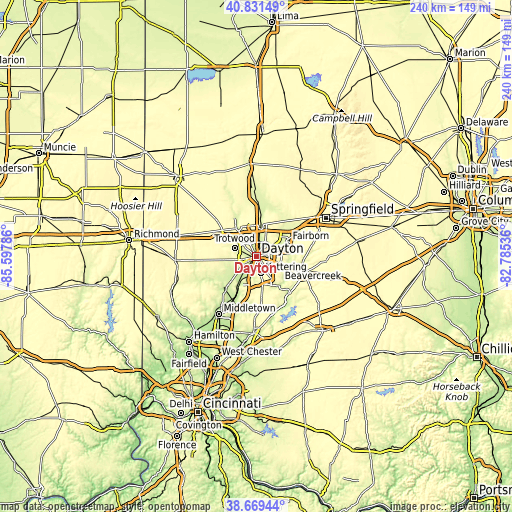
These maps also provides idea of topography and contour of this city, they are displayed at different zoom levels. More info about maps, scale and edge coordinates you can find below images.
| \ | Map #1 | Map #2 | Topo.Map |
| Scale [m] | 191..311 m | 191..320 m | × |
| Scale [ft] | 627..1020 ft | 627..1050 ft | × |
| Average | 239.4 m = 785 ft | 255.3 m = 838 ft | × |
| Width | 7.51 km = 4.7 mi | 15.03 km = 9.3 mi | 240.4 km = 149.4 mi |
| Height | 7.51 km = 4.7 mi | 15.03 km = 9.3 mi | 240.4 km = 149.4 mi |
| ↑Max Latitude | 39.792724° | 39.826482° | 40.83149° |
| Latitude at center | 39.75895° | 39.75895° | 39.75895° |
| ↓Min Latitude | 39.725159° | 39.691352° | 38.66944° |
| ← Min Longitude | -84.235555° | -84.279501° | -85.59786° |
| Longitude center | -84.19161° | -84.19161° | -84.19161° |
| →Max Longitude | -84.147665° | -84.103719° | -82.78536° |
Nearby cities:
Cities around Dayton sort by population:
• Kettering elevation 307 m
8 km,  165°
165°
• Beavercreek 267 m
12.3 km,  116°
116°
• Huber Heights 284 m
11 km,  31°
31°
• Riverside 239 m
6.2 km,  68°
68°
• Trotwood 255 m
11.1 km,  292°
292°
• West Carrollton City 219 m
10.9 km,  208°
208°
• Shiloh 250 m
7.4 km,  334°
334°
• Oakwood 303 m
4 km,  158°
158°
• Northridge 244 m
5.4 km,  355°
355°
• Moraine 226 m
6.3 km,  202°
202°
• Fort McKinley 281 m
6.8 km,  309°
309°
• Drexel 289 m
8.2 km,  260°
260°
Multilingual:
 En español:
Dayton elevación 237 m.
 En France:
Dayton élévation 237 m.


Sources and notes:
- [note 1] Map square and city borders are not equal. Map elevation data is calculated only from area inside that square.
- [src 1] Elevation data from geonames database provided with same terms of usage.
- [src 2] The elevation map of Dayton is generated using elevation data from NASA's 3 arcsec (90m) resolution SRTM data.
- [src 3] Base (background) map © OpenStreetMap contributors tiles are generated by Geofabrik and OpenTopoMap.
Copyright & License:
This Dayton Elevation Map is licensed under CC BY-SA. You may reuse any part from this page, if you give a proper credit by linking to this URL:
 More info on terms of use page.