Cincinnati elevation
Cincinnati (Ohio, Hamilton County), United States elevation is 267 meters and Cincinnati elevation in feet is 876 ft above sea level [src 1]. Cincinnati is a seat of a second-order administrative division (feature code) with elevation that is 12 meters (39 ft) smaller than average city elevation in United States.
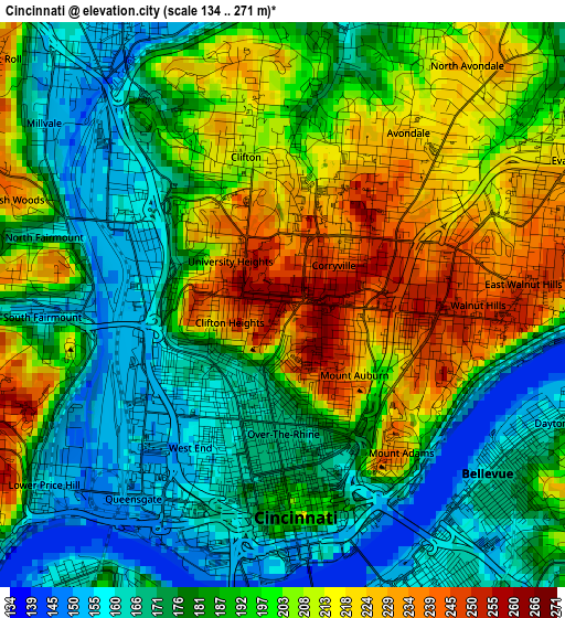
Below is the Elevation map of Cincinnati, which displays elevation range with different colors. Scale of the first map is from 134 to 271 m (440 to 889 ft) with average elevation of 191.4 meters (=628 ft) [note 1]
These maps also provides idea of topography and contour of this city, they are displayed at different zoom levels. More info about maps, scale and edge coordinates you can find below images.
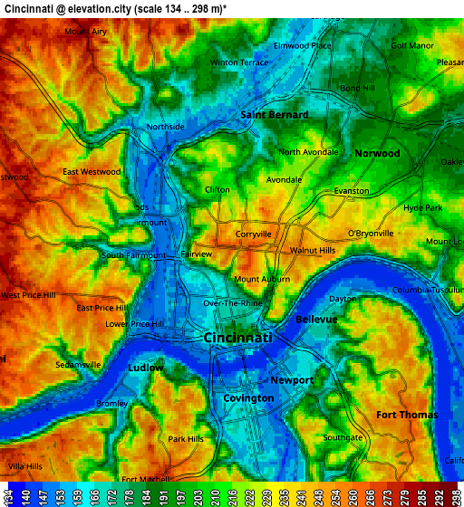
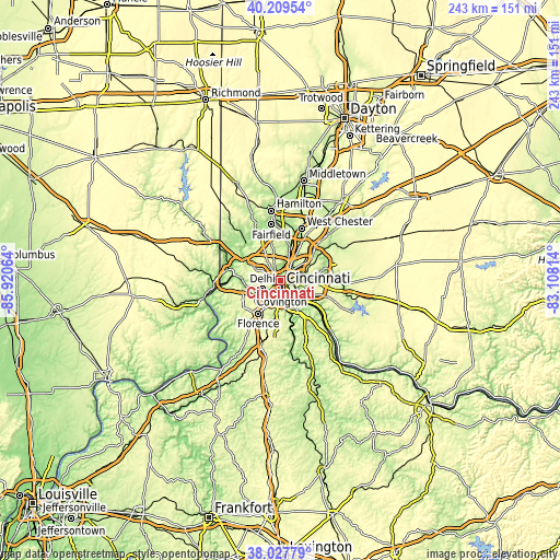
| \ | Map #1 | Map #2 | Topo.Map |
| Scale [m] | 134..271 m | 134..298 m | × |
| Scale [ft] | 440..889 ft | 440..978 ft | × |
| Average | 191.4 m = 628 ft | 206.7 m = 678 ft | × |
| Width | 7.58 km = 4.7 mi | 15.16 km = 9.4 mi | 242.6 km = 150.7 mi |
| Height | 7.58 km = 4.7 mi | 15.16 km = 9.4 mi | 242.6 km = 150.7 mi |
| ↑Max Latitude | 39.161192° | 39.195258° | 40.20954° |
| Latitude at center | 39.12711° | 39.12711° | 39.12711° |
| ↓Min Latitude | 39.093011° | 39.058896° | 38.02779° |
| ← Min Longitude | -84.558335° | -84.602281° | -85.92064° |
| Longitude center | -84.51439° | -84.51439° | -84.51439° |
| →Max Longitude | -84.470445° | -84.426499° | -83.10814° |
Nearby cities:
Cities around Cincinnati sort by population:
• Covington elevation 157 m
4.9 km,  174°
174°
• Norwood 202 m
5.7 km,  56°
56°
• Newport 158 m
4.3 km,  157°
157°
• Fort Mitchell 266 m
8 km,  200°
200°
• Covedale 271 m
8 km,  265°
265°
• Bellevue 169 m
3.8 km,  126°
126°
• Dayton 159 m
3.9 km,  113°
113°
• Ludlow 165 m
4.8 km,  216°
216°
• Saint Bernard 171 m
4.6 km,  17°
17°
• Southgate 213 m
7.1 km,  149°
149°
• Park Hills 231 m
6.4 km,  193°
193°
• Elmwood Place 160 m
7.1 km, 18°
Multilingual:
 En español:
Cincinnati elevación 267 m.
 En France:
Cincinnati élévation 267 m.
 Auf Deutsch:
Cincinnati höhe über dem Meeresspiegel ist 267 m.

Sources and notes:
- [note 1] Map square and city borders are not equal. Map elevation data is calculated only from area inside that square.
- [src 1] Elevation data from geonames database provided with same terms of usage.
- [src 2] The elevation map of Cincinnati is generated using elevation data from NASA's 3 arcsec (90m) resolution SRTM data.
- [src 3] Base (background) map © OpenStreetMap contributors tiles are generated by Geofabrik and OpenTopoMap.
Copyright & License:
This Cincinnati Elevation Map is licensed under CC BY-SA. You may reuse any part from this page, if you give a proper credit by linking to this URL:
 More info on terms of use page.