Statesville elevation
Statesville (North Carolina, Iredell County), United States elevation is 281 meters and Statesville elevation in feet is 922 ft above sea level [src 1]. Statesville is a seat of a second-order administrative division (feature code) with elevation that is 2 meters (7 ft) bigger than average city elevation in United States.
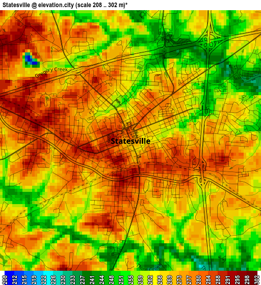
Below is the Elevation map of Statesville, which displays elevation range with different colors. Scale of the first map is from 208 to 302 m (682 to 991 ft) with average elevation of 268.1 meters (=880 ft) [note 1]
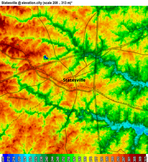
These maps also provides idea of topography and contour of this city, they are displayed at different zoom levels. More info about maps, scale and edge coordinates you can find below images.
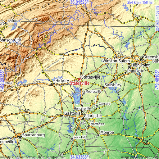
| \ | Map #1 | Map #2 | Topo.Map |
| Scale [m] | 208..302 m | 208..313 m | × |
| Scale [ft] | 682..991 ft | 682..1027 ft | × |
| Average | 268.1 m = 880 ft | 270 m = 886 ft | × |
| Width | 7.93 km = 4.9 mi | 15.86 km = 9.9 mi | 253.7 km = 157.6 mi |
| Height | 7.93 km = 4.9 mi | 15.86 km = 9.9 mi | 253.7 km = 157.6 mi |
| ↑Max Latitude | 35.818282° | 35.853908° | 36.91523° |
| Latitude at center | 35.78264° | 35.78264° | 35.78264° |
| ↓Min Latitude | 35.746982° | 35.711308° | 34.63368° |
| ← Min Longitude | -80.931245° | -80.975191° | -82.29355° |
| Longitude center | -80.8873° | -80.8873° | -80.8873° |
| →Max Longitude | -80.843355° | -80.799409° | -79.48105° |
Nearby cities:
Cities around Statesville sort by population:
• Mooresville elevation 276 m
23.1 km,  162°
162°
• Davidson 242 m
31.5 km,  172°
172°
• Conover 326 m
31.1 km,  254°
254°
• Lake Norman of Catawba 231 m
25.3 km,  207°
207°
• Mocksville 262 m
31.9 km,  67°
67°
• Lake Norman of Catawba 247 m
22.7 km,  196°
196°
• Troutman 286 m
9.1 km,  180°
180°
• Denver 276 m
30.8 km, 204°
• Taylorsville 377 m
30.3 km,  300°
300°
• Claremont 298 m
24.6 km, 252°
• Stony Point 323 m
17 km, 301°
• Sherrills Ford 274 m
20.1 km, 206°
Multilingual:
 En español:
Statesville elevación 281 m.
 En France:
Statesville élévation 281 m.
 Auf Deutsch:
Statesville höhe über dem Meeresspiegel ist 281 m.

Sources and notes:
- [note 1] Map square and city borders are not equal. Map elevation data is calculated only from area inside that square.
- [src 1] Elevation data from geonames database provided with same terms of usage.
- [src 2] The elevation map of Statesville is generated using elevation data from NASA's 3 arcsec (90m) resolution SRTM data.
- [src 3] Base (background) map © OpenStreetMap contributors tiles are generated by Geofabrik and OpenTopoMap.
Copyright & License:
This Statesville Elevation Map is licensed under CC BY-SA. You may reuse any part from this page, if you give a proper credit by linking to this URL:
 More info on terms of use page.