Lewisville elevation
Lewisville (North Carolina, Forsyth County), United States elevation is 297 meters and Lewisville elevation in feet is 974 ft above sea level [src 1]. Lewisville is a populated place (feature code) with elevation that is 18 meters (59 ft) bigger than average city elevation in United States.
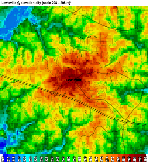
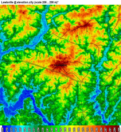
Below is the Elevation map of Lewisville, which displays elevation range with different colors. Scale of the first map is from 208 to 298 m (682 to 978 ft) with average elevation of 256.2 meters (=841 ft) [note 1]
These maps also provides idea of topography and contour of this city, they are displayed at different zoom levels. More info about maps, scale and edge coordinates you can find below images.
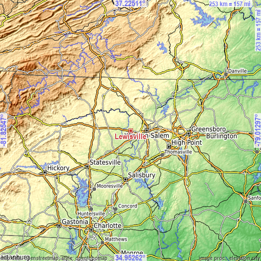
| \ | Map #1 | Map #2 | Topo.Map |
| Scale [m] | 208..298 m | 206..298 m | × |
| Scale [ft] | 682..978 ft | 676..978 ft | × |
| Average | 256.2 m = 841 ft | 247.4 m = 812 ft | × |
| Width | 7.9 km = 4.9 mi | 15.79 km = 9.8 mi | 252.7 km = 157 mi |
| Height | 7.9 km = 4.9 mi | 15.79 km = 9.8 mi | 252.7 km = 157 mi |
| ↑Max Latitude | 36.132581° | 36.168065° | 37.22511° |
| Latitude at center | 36.09708° | 36.09708° | 36.09708° |
| ↓Min Latitude | 36.061563° | 36.026031° | 34.95262° |
| ← Min Longitude | -80.463165° | -80.507111° | -81.82547° |
| Longitude center | -80.41922° | -80.41922° | -80.41922° |
| →Max Longitude | -80.375275° | -80.331329° | -79.01297° |
Nearby cities:
Cities around Lewisville sort by population:
• Winston-Salem elevation 283 m
15.7 km,  88°
88°
• Clemmons 255 m
9 km,  158°
158°
• King 338 m
21.1 km,  14°
14°
• Mocksville 262 m
26 km,  209°
209°
• Walkertown 302 m
25.4 km,  69°
69°
• Midway 271 m
24.1 km,  131°
131°
• Welcome 262 m
26.1 km,  145°
145°
• Rural Hall 309 m
19.5 km,  35°
35°
• Yadkinville 293 m
22 km,  280°
280°
• Tobaccoville 311 m
16.3 km,  15°
15°
• Bermuda Run 244 m
10.4 km,  181°
181°
• Advance 252 m
17.3 km, 177°
Multilingual:
 En español:
Lewisville elevación 297 m.
 En France:
Lewisville élévation 297 m.
 Auf Deutsch:
Lewisville höhe über dem Meeresspiegel ist 297 m.

Sources and notes:
- [note 1] Map square and city borders are not equal. Map elevation data is calculated only from area inside that square.
- [src 1] Elevation data from geonames database provided with same terms of usage.
- [src 2] The elevation map of Lewisville is generated using elevation data from NASA's 3 arcsec (90m) resolution SRTM data.
- [src 3] Base (background) map © OpenStreetMap contributors tiles are generated by Geofabrik and OpenTopoMap.
Copyright & License:
This Lewisville Elevation Map is licensed under CC BY-SA. You may reuse any part from this page, if you give a proper credit by linking to this URL:
 More info on terms of use page.