Kenansville elevation
Kenansville (North Carolina, Duplin County), United States elevation is 43 meters and Kenansville elevation in feet is 141 ft above sea level [src 1]. Kenansville is a seat of a second-order administrative division (feature code) with elevation that is 236 meters (774 ft) smaller than average city elevation in United States.
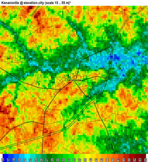
Below is the Elevation map of Kenansville, which displays elevation range with different colors. Scale of the first map is from 15 to 55 m (49 to 180 ft) with average elevation of 35.5 meters (=116 ft) [note 1]
These maps also provides idea of topography and contour of this city, they are displayed at different zoom levels. More info about maps, scale and edge coordinates you can find below images.
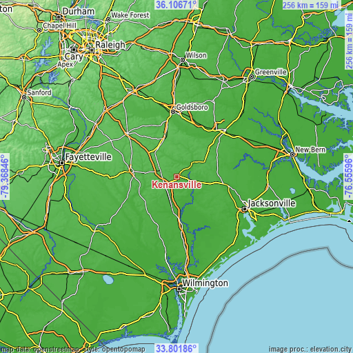
| \ | Map #1 | Topo.Map |
| Scale [m] | 15..55 m | × |
| Scale [ft] | 49..180 ft | × |
| Average | 35.5 m = 116 ft | × |
| Width | 8.01 km = 5 mi | 256.3 km = 159.3 mi |
| Height | 8.01 km = 5 mi | 256.3 km = 159.3 mi |
| ↑Max Latitude | 34.998397° | 36.10671° |
| Latitude at center | 34.96239° | 34.96239° |
| ↓Min Latitude | 34.926368° | 33.80186° |
| ← Min Longitude | -78.006155° | -79.36846° |
| Longitude center | -77.96221° | -77.96221° |
| →Max Longitude | -77.918265° | -76.55596° |
Nearby cities:
Cities around Kenansville sort by population:
• Clinton elevation 47 m
33.1 km,  276°
276°
• Mount Olive 49 m
27.7 km,  339°
339°
• Burgaw 13 m
45.7 km,  175°
175°
• Wallace 15 m
25.4 km,  186°
186°
• Elroy 33 m
42.6 km,  6°
6°
• Mar-Mac 35 m
42.3 km,  348°
348°
• Warsaw 48 m
12.4 km,  289°
289°
• La Grange 33 m
41.4 km,  22°
22°
• Brogden 55 m
37.3 km, 349°
• Richlands 16 m
38.5 km,  100°
100°
• Rose Hill 32 m
15.9 km,  200°
200°
• Beulaville 25 m
17.7 km, 104°
Multilingual:
 En español:
Kenansville elevación 43 m.
 En France:
Kenansville élévation 43 m.
 Auf Deutsch:
Kenansville höhe über dem Meeresspiegel ist 43 m.

Sources and notes:
- [note 1] Map square and city borders are not equal. Map elevation data is calculated only from area inside that square.
- [src 1] Elevation data from geonames database provided with same terms of usage.
- [src 2] The elevation map of Kenansville is generated using elevation data from NASA's 3 arcsec (90m) resolution SRTM data.
- [src 3] Base (background) map © OpenStreetMap contributors tiles are generated by Geofabrik and OpenTopoMap.
Copyright & License:
This Kenansville Elevation Map is licensed under CC BY-SA. You may reuse any part from this page, if you give a proper credit by linking to this URL:
 More info on terms of use page.