Jacksonville elevation
Jacksonville (North Carolina, Onslow County), United States elevation is 7 meters and Jacksonville elevation in feet is 23 ft above sea level [src 1]. Jacksonville is a seat of a second-order administrative division (feature code) with elevation that is 272 meters (892 ft) smaller than average city elevation in United States.
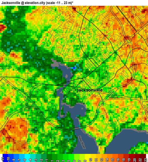
Below is the Elevation map of Jacksonville, which displays elevation range with different colors. Scale of the first map is from -11 to 23 m (-36 to 75 ft) with average elevation of 7.2 meters (=24 ft) [note 1]
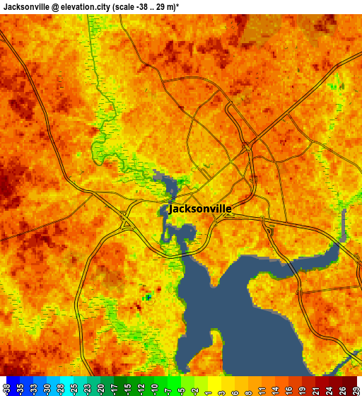
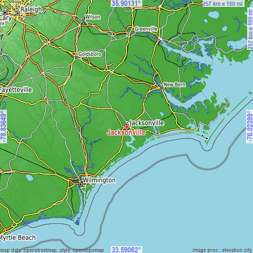
These maps also provides idea of topography and contour of this city, they are displayed at different zoom levels. More info about maps, scale and edge coordinates you can find below images.
| \ | Map #1 | Map #2 | Topo.Map |
| Scale [m] | -11..23 m | -38..29 m | × |
| Scale [ft] | -36..75 ft | -125..95 ft | × |
| Average | 7.2 m = 24 ft | 9.5 m = 31 ft | × |
| Width | 8.03 km = 5 mi | 16.06 km = 10 mi | 256.9 km = 159.6 mi |
| Height | 8.03 km = 5 mi | 16.06 km = 10 mi | 256.9 km = 159.6 mi |
| ↑Max Latitude | 34.790148° | 34.82623° | 35.90131° |
| Latitude at center | 34.75405° | 34.75405° | 34.75405° |
| ↓Min Latitude | 34.717936° | 34.681807° | 33.59062° |
| ← Min Longitude | -77.474185° | -77.518131° | -78.83649° |
| Longitude center | -77.43024° | -77.43024° | -77.43024° |
| →Max Longitude | -77.386295° | -77.342349° | -76.02399° |
Nearby cities:
Cities around Jacksonville sort by population:
• Piney Green elevation 10 m
10.9 km,  112°
112°
• Half Moon 7 m
8.4 km,  341°
341°
• Swansboro 4 m
29.4 km,  104°
104°
• Sneads Ferry 8 m
22.6 km,  172°
172°
• Pumpkin Center 8 m
6.7 km,  51°
51°
• Holly Ridge 18 m
30.9 km,  201°
201°
• Cape Carteret 8 m
34.3 km, 101°
• Richlands 16 m
19.3 km,  326°
326°
• Beulaville 25 m
36.6 km,  301°
301°
• Cedar Point 7 m
33.5 km, 102°
• Maysville 12 m
24.7 km, 47°
• Trenton 1 m
35.5 km,  11°
11°
Multilingual:
 En español:
Jacksonville elevación 7 m.
 En France:
Jacksonville élévation 7 m.
 Auf Deutsch:
Jacksonville höhe über dem Meeresspiegel ist 7 m.
 На русском:
Джексонвилл, Джэксонвилл высота над уровнем моря 7 м
Sources and notes:
- [note 1] Map square and city borders are not equal. Map elevation data is calculated only from area inside that square.
- [src 1] Elevation data from geonames database provided with same terms of usage.
- [src 2] The elevation map of Jacksonville is generated using elevation data from NASA's 3 arcsec (90m) resolution SRTM data.
- [src 3] Base (background) map © OpenStreetMap contributors tiles are generated by Geofabrik and OpenTopoMap.
Copyright & License:
This Jacksonville Elevation Map is licensed under CC BY-SA. You may reuse any part from this page, if you give a proper credit by linking to this URL:
 More info on terms of use page.